River Thames from source to sea
![Creative Commons Licence [Some Rights Reserved]](https://s1.geograph.org.uk/img/somerights20.gif)
Great Britain 1:50 000 Scale Colour Raster Mapping Extracts © Crown copyright Ordnance Survey. All Rights Reserved. Educational licence 100045616.
Contents
- Brief Introduction
- Thames Head to Ashton Keynes
- Ashton Keynes to Cricklade
- Cricklade to Lechlade
- Lechlade to Newbridge
- Newbridge to Oxford
- Oxford to Abingdon
- Abingdon to Wallingford
- Wallingford to Goring-on-Thames
- Goring-on-Thames to Tileshurst,Reading
- Tilehurst, Reading to Henley-on-Thames
- Henley-on-Thames to Marlow
- Marlow to Windsor
- Windsor to Shepperton
- Shepperton to Teddington
- Teddington to Putney
- Putney to Thames Barrier
- Thames Barrier to Grays
- Grays to Gravesend
- Gravesend and the Shore Forts
- The Essex Shore to the Crowstone and Southend-on-Sea
- The Kent Shore to the London Stone
- Into the Thames Estuary
Tilehurst, Reading to Henley-on-Thames
SU6775
 Map © Crown Copyright")
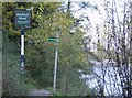
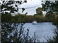
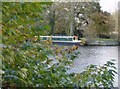
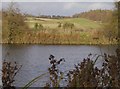
The reach beside Tilehurst Station is known as the Kentwood Deeps.
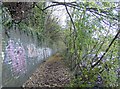
The Thames Path leaves the river to avoid properties on the South Bank. At one stage a ferry allowed the path to continue on the other bank.
Suggested format for contributions
[[SU????]]
[map SU?????]
Text here
[[[*******]]]
Great Britain 1:50 000 Scale Colour Raster Mapping Extracts © Crown copyright Ordnance Survey. All Rights Reserved. Educational licence 100045616.
( Page < < prev 1 ... 5 6 7 8 9 10 11 12 13 14 15 16 17 ... next >> )