Page 5
Kennet Avon Canal Newbury to Devizes
![Creative Commons Licence [Some Rights Reserved]](https://s1.geograph.org.uk/img/somerights20.gif)
Great Britain 1:50 000 Scale Colour Raster Mapping Extracts © Crown copyright Ordnance Survey. All Rights Reserved. Educational licence 100045616.
Contents
- NEWBURY
- Newbury Bridge No.32: Newbury Lock No.85: John Gould Memorial: West Mills Swing Bridge No.33:
- West Mills: West Mills Swing Bridge No.33: Northcroft Bridge No.34:
- Guyers Lock No.84: Enborne Bridge No.35:
- Guyers Lock No.84: Enborne Bridge No.35:
- Newbury Bypass: Higg's Lock No.83:
- Pickletimber Railway Bridge:
- Benham Bridge No.37: Benham Lock No.82:
- Hamstead Bridge No.38: Hamstead Lock No.81:
- Copse Lock No.80: Dreweat's Bridge No.39: Dreweat's Lock No.79:
- Dreweat's Lock No.79: Irish Hill:
- Shepherd's Bridge No.40:
- Kintbury Bridge No.41: Kintbury Lock No.78: Vicarage Bridge No.42:
- Orchard Meadow Bridge No.43: Brunsden Lock Bridge No.44: Brunsden Lock No.77:
- Railway Bridge No.45:
- Wire Lock Bridge No.45: Wire Lock No.76:
- Dunmill Lock Bridge No.46: Dunmill Lock No.75:
- Station Road Bridge No.48:
- Hungerford Town Bridge No.49: Hungerford Wharf: Hungerford Lock No.74: Hungerford Church Swing Bridge No.50:
- Hungerford Marsh Swing Bridge No.51: Hungerford Marsh Lock 72: Cobbler's Lock Footbridge No.52: Cobbler's Lock No.72:
- Barrackfield Swing Bridge: Railway Bridge No.54: Picketfield Lock No.71:
- Froxfield Bridge No.55: Froxfield Bottom Lock No.70: Froxfield Middle Lock No.69:
- Oakhill Down Bridge No.56: Oakhill Down Lock No.68:
- Fore Bridge No.57: Little Bedwin Footbridge: Little Bedwin Lock No.67:
- Little Bedwin Lock No.67: Little Bedwin Bridge No.58:
- Potter's Lock No.66:
- Burnt Mill Footbridge No.59: Burnt Mill Lock No.65: Bedwyn Wharf Bridge No.60:
- Bedwyn Church Bridge No.61: Bedwyn Church Lock No.64:
- Mill Bridge No.62: Beech Tree Walk Bridge No.98: Beech Grove Lock No.63: New Bridge No.99:
- Crofton Lock No.62: Crofton Crossing Bridge No.100: Crofton Lock No.61: Crofton Lock No.60: Wilton Water: Crofton Pumping Station: Crofton Lock No.59:
- Freewarren Bridge No.101: Sam Farmer Lock No.58: Crofton Lock No.57: Crofton Lock No.56:
- Wolfhall Fields Bridge No.102: Crofton Top Lock No.55: Wolfhall Bridge No.103:
- Bruce Tunnel:
- Burbage Wharf Bridge No.104: Burbage Wharf:
- Wootton Top - Cadley Lock No.54: Cadley Bridge No.105: Brimslade Lock No.53: Brimslade Bridge No.106:
- Brimslade Bridge No.106: Brimslade Lock No.53: Heathey Close Lock No.52: Heathey Close Bridge No.107:
- Wootton Rivers Bottom Lock No.51: Wootton Rivers Bridge No.108: Wootton Rivers Farm Bridge No.109: Carrel Crown Bridge No.110:
- New Mill Bridge No.111:
- Milkhouse Water Bridge No.112:
- Pains Bridge No.113:
- Pewsey Wharf: Pewsey Bridge No.114: Bristow Bridge No.115:
- Stowell Park Footbridge No.116: Wilcot Bridge No.117:
- Wilcot Swing Bridge No.118: Bowdens Bridge No.119:
- Wilcot Wide Water:
- Lady's or Ladies Bridge No.120:
- Woodborough Fields Bridge No.121:
- Alton Valley Bridge No.123: Honey Street Bridge No.124:
- Stanton Bridge No.125:
- England's Bridge No.126:
- All Cannings Bridge No.127: Woodway Bridge No.128:
- Allington Swing Bridge No.129:
- Allington Bridge No.130: Norton Fields Swing Bridge No.131:
- Horton Chain Bridge No.132
- Bishops Cannings Swing Bridge No.133
- Horton Bridge No.134
- Laywood Bridge No.135
- Devizes Marina
- Coate Bridge No.136: Brickham Bridge No.137:
- London Road Bridge No.138
- Park Bridge No.139: Cemetery Road Bridge No.140: Devizes Wharf:
- DEVIZES
 Map © Crown Copyright") | SU3568 |
Dunmill Lock Bridge No.46: Dunmill Lock No.75:
| SU3568 | 2009 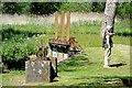 | 2009 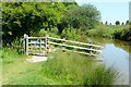 |
2009 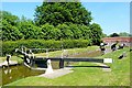 | 2010 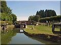 | |
2010 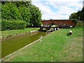 | ||
2008 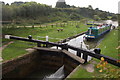 | ||
2010 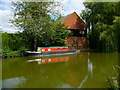 | ||
2009 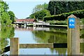 | ||
2008 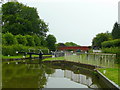 | ||
2010 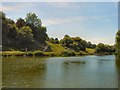 | ||
2010
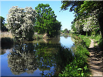
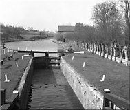
A spring-time view along the canal with Dunmill Bridge visible in the distance.
by Andrew Smith
2009
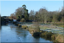
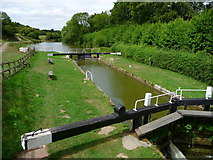
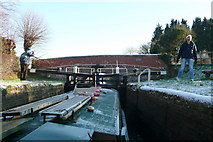
The canal had about half an inch of ice on it here, on the open section below Dun Mill lock with the River Kennet off to the right. The ice made for an interesting (read difficult) turn for the trip boat at the winding hole, 300 metres east of here. The passengers did not mind or notice - Santa was on board.
by Graham Horn
2009
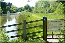
This is the easterly extent of Portdown or Hungerford Common, which includes the section between the canal and the river from here to Dun Mill. The Common is still owned by the town of Hungerford. In the distance is Dun Mill Lock bridge.
by Graham Horn
2009
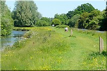
On the left is the River Kennet. On the right, a few feet higher, is the Kennet and Avon Canal. The canal follows the Dun valley from Crofton to near here where the River Dun joins the River Kennet. At times the River Kennet is higher than the canal (not here) and various weirs allow the canal to be fed by the river and to get rid of any excess. Here the towpath runs between the two.
by Graham Horn
2008
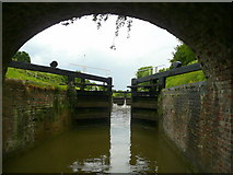
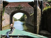
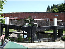
Entering Dun Mill Lock from the east.
by Jonathan Billinger
2010
1976
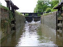
For the westward-travelling boatman, this is the last lock before Hungerford on this very pleasant stretch of canal.
by Dr Neil Clifton
2009
Looking into the lock from the Rose of Hungerford.
by Maigheach-gheal
It should be noted here that Graham Horn is one of the skippers on "Rose of Hungerford"
2009
We had to de-ice the boat before we could safely use it. We have Santa on board having met him at the lock, and with a sprinkling of snow the children (aged 8 months to 80 years), were enjoying themselves. I was outside on the helm, getting cold but enjoying ice-breaking.
by Graham Horn
It should also be noted that ice breaking with a narrowboat, especially a 70 footer with passengers, is a task requiring far more skill than is apparent to a casual bystander. MEP
2010
Dun Mill Lock was built between 1794 and 1804 under the supervision of the engineer John Rennie. The canal is administered by British Waterways. The lock has a rise/fall of 5 ft 8 in (1.73 m). It is a grade II listed building
Link
Link
by Paul Gillett
2010
2009
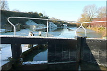
A very cold and frosty Sunday before Christmas, with a sprinkling of snow, a covering of ice on the canal that we had to break, and we needed to be very careful around the lock. We were on Rose of Hungerford trip boat and had just picked up Santa Claus.
by Graham Horn
Great Britain 1:50 000 Scale Colour Raster Mapping Extracts © Crown copyright Ordnance Survey. All Rights Reserved. Educational licence 100045616.
( Page < < prev 1 2 3 4 5 6 7 8 9 10 11 12 ... next >> )