2003
TF4068 : Monk's Field - A burial site or a by-pass?
taken 20 years ago, near to Partney, Lincolnshire, England
This is 1 of 3 images, with title Monk's Field - A burial site or a by-pass? in this square
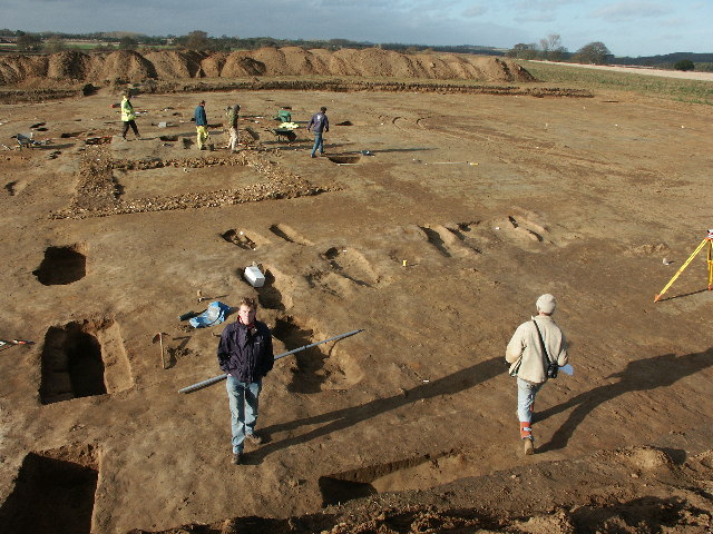
Monk's Field - A burial site or a by-pass?
Unfortunately the latter. Below is a report from a site on the Internet about the dig and has been slightly reduced in size and brought into the present tense.
"This archaeological site of national importance was uncovered at Partney, Lincolnshire, after being hidden for hundreds of years beneath the soil. Burial sites were revealed during the digging of an evaluation trench in a field next to the A158 road for the village bypass. Lincolnshire County Council contacted the archaeological field unit, whose work revealed remains of the Chapel of St Mary Magdalen - a Benedictine cell of Bardney Abbey - a cemetery containing 44 bodies, and a medieval hospital dating back to the 11th century. Excavations of the site which were carried out over six weeks, also uncovered evidence of a Romano-British farmstead and an early Iron Age enclosure.
The archaeological Site Manager said that there were only about 60 of such minor hospitals in the country, and this was the first to have been excavated. Some of the bodies had been buried with chalices of gold and silver and others with pewter, a symbolic metal signifying the deceased's status as a priest. Their bones will be interred at a later date, and the finds, including coins, clasps, and fragments of medieval pottery will be held for research at the City and County Museum, Lincoln. Once excavations are completed the site will be hidden again, to be covered over by the bypass."
The whole dig - Link
The by-pass - Link
 Map © Crown Copyright")
TIP: Click the map for more Large scale mapping
- Grid Square
- TF4068, 18 images (more nearby 🔍)
- Photographer
- Dave Hitchborne (more nearby)
- Date Taken
- Friday, 14 November, 2003 (more nearby)
- Submitted
- Thursday, 5 January, 2006
- Subject Location
-
OSGB36:
 TF 406 683 [100m precision]
WGS84: 53:11.6131N 0:6.2305E - Camera Location
-
OSGB36: TF 407 683
- View Direction
- WEST (about 270 degrees)