2008
NS3377 : The ruins of Murrays (AA Battery Cardross)
taken 15 years ago, near to Geilston, Argyll And Bute, Scotland
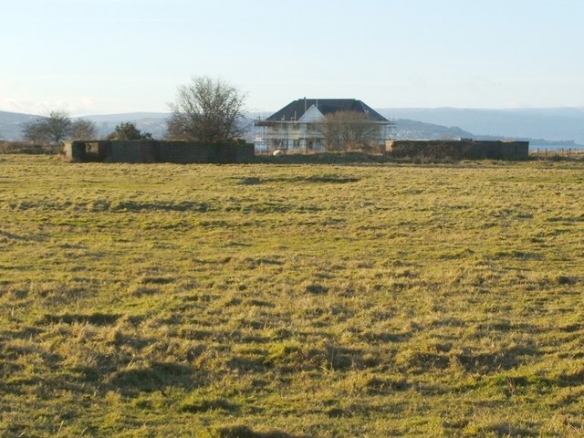
The ruins of Murrays (AA Battery Cardross)
The main point of interest here is not the house with scaffolding that appears in the background (which is Seabank Cottage - NS3377 : Seabank Cottage), but the ruins that stand in front of it.
As is revealed on the 1:25000 map, and is also evident from aerial/satellite imagery, these ruins are clustered in an unusual pattern. In fact, these are some of the remains of Anti-Aircraft Battery Cardross, which was also known as Murrays; for a great deal more information about this emplacement, and pictures of the site, see the following article at the Secret Scotland website: Link (Archive Link )
The battery at Murrays formed part of the Clyde Anti-Aircraft defences, and was listed as "Anti-aircraft gun emplacement AN4" (compare another gun emplacement at Mugdock: NS5477 : Anti-aircraft gun emplacement N9 - inside the bunker).
In the following related items, I've tried to employ the same numbering of emplacements as was used on the Secret Scotland site:
Gun emplacements:
NS3377 : Murrays - first gun emplacement
NS3377 : Murrays - second gun emplacement
NS3377 : Murrays - third gun emplacement
NS3377 : Murrays - fourth gun emplacement
NS3377 : Murrays - fifth gun emplacement
NS3377 : Murrays - sixth gun emplacement
Other buildings:
NS3377 : Murrays - command post
NS3377 : Murrays - accommodation camp (ruins)
NS3377 : Murrays - possible site of latrine block
As is revealed on the 1:25000 map, and is also evident from aerial/satellite imagery, these ruins are clustered in an unusual pattern. In fact, these are some of the remains of Anti-Aircraft Battery Cardross, which was also known as Murrays; for a great deal more information about this emplacement, and pictures of the site, see the following article at the Secret Scotland website: Link
The battery at Murrays formed part of the Clyde Anti-Aircraft defences, and was listed as "Anti-aircraft gun emplacement AN4" (compare another gun emplacement at Mugdock: NS5477 : Anti-aircraft gun emplacement N9 - inside the bunker).
In the following related items, I've tried to employ the same numbering of emplacements as was used on the Secret Scotland site:
Gun emplacements:
NS3377 : Murrays - first gun emplacement
NS3377 : Murrays - second gun emplacement
NS3377 : Murrays - third gun emplacement
NS3377 : Murrays - fourth gun emplacement
NS3377 : Murrays - fifth gun emplacement
NS3377 : Murrays - sixth gun emplacement
Other buildings:
NS3377 : Murrays - command post
NS3377 : Murrays - accommodation camp (ruins)
NS3377 : Murrays - possible site of latrine block
Murrays (AA Battery Cardross)
Remains of a Second World War anti-aircraft battery.
 Map © Crown Copyright")
TIP: Click the map for more Large scale mapping
- Grid Square
- NS3377, 57 images (more nearby 🔍)
- Photographer
- Lairich Rig (more nearby)
- Date Taken
- Wednesday, 10 December, 2008 (more nearby)
- Submitted
- Friday, 12 December, 2008
- Subject Location
-
OSGB36:
 NS 3370 7727 [10m precision]
WGS84: 55:57.5742N 4:39.9310W - Camera Location
-
OSGB36: NS 3384 7729
- View Direction
- WEST (about 270 degrees)