2006
NG2752 : Annait
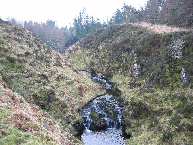
taken 18 years ago, 4 km S of Lusta, Isle of Skye, Scotland
This is 1 of 3 images, with title Annait in this square
Annait
Interesting place, Annait. It is marked 'Annait' on the OS map but I have seen it spelt 'anait' elsewhere. Possibly it should be 'the Annait' or 'an anait', I'm not sure.
It is also difficult to give a decent impression of what it looks like in a photograph. You need to stand on it and look all around to really appreciate it. It is a pointed piece of ground between two small rivers, immediately above their confluence. Each of the rivers flows in a gorge. The photograph here shows the gorge on the left as you look downstream. A quite excellent defensive position. It is not that easy to reach even when nobody is defending it!
There are signs of ruined walls on the top, including one heavy wall that would have once barred access to the point other than by a single entranceway.
What was its purpose? How old is it? Who knows? I have come across some contradictory theories.
The one I tend to believe is that Annat sites, of which there are several in the north west of Scotland, appear to be pre-Christian and apparently relate to the worship of Anaitis, the Mother Goddess of the ancient East. In the old Hebrew-Phoenician pantheon, Anaitis or Anath was the sister of the sun god Baal or Bel who was also worshipped in Scotland and Ireland, by the lighting of Beltane fires. Anaitis, from whence, in all probability, is derived the gaelic term annat, was a pre-Christian female deity or goddess who was worshipped not only in Egypt but also in Palestine and Asia Minor.
Alexander Forbes (Place-Names of Skye -1923) comments: "Many of the Annats are claimedand it is believed correctlyas pre-Christian.
 Map © Crown Copyright")
TIP: Click the map for more Large scale mapping
- Grid Square
- NG2752, 13 images (more nearby 🔍)
- Photographer
- John Allan (more nearby)
- Date Taken
- Wednesday, 1 February, 2006 (more nearby)
- Submitted
- Wednesday, 1 February, 2006
- Subject Location
-
OSGB36:
 NG 272 529 [100m precision]
WGS84: 57:29.0379N 6:33.2076W