1996
NB0332 : Gneiss at Uig Sands, Lewis
taken 28 years ago, near to Ardroil, Isle of Lewis And Harris, Na h-Eileanan an Iar, Scotland
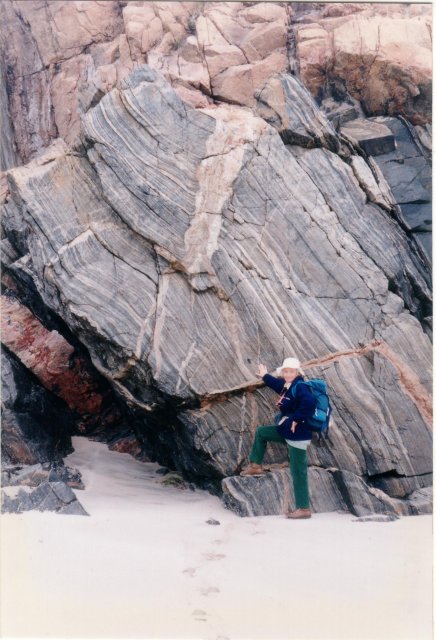
Gneiss at Uig Sands, Lewis
The grey striped rock is Lewisian gneiss, and the pink is late Laxfordian pegmatitic granite. The gneiss is very old (c 3,000 million years), metamorphic (changed by heat and pressure deep in the Earth) and polycyclic (having been buried and resurfaced several times. It underlay a range of Himalayan-height mountains that once lay where the Outer Hebrides now are, but were then eroded to sea level. The granite was intruded into the gneiss about 1,700 million years ago. Many beaches in Lewis are covered with smooth rounded boulders of Lewisian gneiss, showing pink and black stripes most attractively. The gneiss has been dated by various methods, partly by analogy with similar rocks in Greenland, to 3,000 Ma plus or minus a couple of hundred million years. It was formed by compression during a period of continental collision. This was followed around 2900 - 2700 Ma by the main Scourian event, an extensional regime which resulted in the intrusion of the Older Basics, which are more mafic (richer in iron and magnesium) and less silica-rich than the gneiss, and then in the late Scourian, around 2500 to 2400 Ma, by the intrusion of the Younger Basics, which are also more mafic. The Older Basics can be shown to cut the fabric of the gneiss, therefore they are later, and dating the OBs by geophysical methods has provided a minimum age for the gneiss. Around 1900 to 1700 Ma was the main Laxfordian event, another episode of compression and deformation. In the late Laxfordian, 1700 - 1600 Ma, more extension allowed the intrusion of the granites, mainly in the Uig Hills and north Harris. Uplift commenced after the Laxfordian, around 1400 Ma.
[Thanks to Anne Burgess for this description]
[Thanks to Anne Burgess for this description]
 Map © Crown Copyright")
TIP: Click the map for more Large scale mapping
- Grid Square
- NB0332, 27 images (more nearby 🔍)
- Photographer
- John Palmer (more nearby)
- Date Taken
- Wednesday, 22 May, 1996 (more nearby)
- Submitted
- Monday, 16 March, 2009
- Subject Location
-
OSGB36:
 NB 036 324 [100m precision]
WGS84: 58:10.8760N 7:2.6219W - Camera Location
-
OSGB36: NB 036 326
- View Direction
- SOUTH (about 180 degrees)