2009
NS3977 : Mound beside the River Leven
taken 15 years ago, near to Renton, West Dunbartonshire, Scotland
This is 1 of 4 images, with title Mound beside the River Leven in this square
Mound beside the River Leven
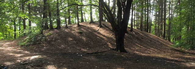
The large rounded mound shown in this image has a distinctly man-made appearance; it stands in isolation on what is now an otherwise flat area of land.
It is hard to get an accurate sense of scale from this image, but the mound measures 35 metres across; its height is therefore about 6 metres (NS3977 : Top of a mound). Maps from the latter half of the nineteenth century show the mound, but leave it unexplained. A report at WoSAS has some comments on the site: Link
Two traditional explanations have come down to me, indirectly, from a former head gardener of Strathleven Estate. The first is that this is a burial mound; however, for reasons that are given below, it seems unlikely that this particular mound is an antiquity of that kind. The second proposed explanation is that the mound was created for the occupants of nearby Strathleven House (NS3978 : Strathleven House, built c.1690), who did not wish to see the huge cones of Dumbarton Glassworks from the windows of their home (these three cones dominated the Dumbarton skyline from c.1777 to 1850, and stood at what is now the site of NS3975 : Dumbarton Health Centre; see NS3975 : The Artizan Bridge).
I carried out the necessary calculations to confirm that mound does indeed lie exactly on the line between the house and the former glassworks' location; this does not prove that the explanation is correct, but it does at least show it to be plausible. A large, bare mound of soil would probably be no less an eyesore than the glassworks had been, but the planting of trees on and around it would have improved its appearance, and would greatly have increased the height of the area blocked from view (not only were the cones of the glassworks tall, but they would have produced much smoke).
The WoSAS link cited above mentions what appears to be a bank or levee, probably flood defences, depicted on the first-edition OS map of c.1860 as extending eastwards from the mound, but now gone (see NS3977 : View from mound). On a later occasion, I noticed a river embankment that may have been the base upon which those defences were built: NS3977 : Old embankment (detail).
On NW side of the mound itself, set precisely at the foot of the slope, are some sections of a line of stones, consisting of a single course of large blocks of red sandstone; the line curves to follow the line of the mound's outer edge: NS3977 : Remnants of mound's kerb. This was probably built to demarcate or contain the base of the mound. I looked for traces of similar lines of stones on the other sides of the mound, but found none.
The presence of traces of a bounding wall of no great antiquity means that, of the two traditional explanations given above for this mound, the second of them (namely, that it was built to block Dumbarton Glassworks from view) is by far the more likely.
Mound beside the River Leven
A conspicuous artificial mound beside the River Leven, and shown on early maps, opposite the end of Dalquhurn Point. Of the theories about its origin, a plausible one is that it was built by the occupants of Strathleven House to block the cones (and smoke) of Dumbarton Glassworks (c.17771850) from view; the mound does indeed lie on the line between the house and the former glassworks site. Indistinct remains of a kerb can be seen on the western side of its base.
 Map © Crown Copyright")
TIP: Click the map for more Large scale mapping
- Grid Square
- NS3977, 336 images (more nearby 🔍)
- Photographer
- Lairich Rig (more nearby)
- Date Taken
- Friday, 28 August, 2009 (more nearby)
- Submitted
- Wednesday, 2 September, 2009
- Subject Location
-
OSGB36:
 NS 3960 7791 [10m precision]
WGS84: 55:58.0392N 4:34.2897W - Camera Location
-
OSGB36: NS 3962 7796
- View Direction
- South-southwest (about 202 degrees)