2009
NS4573 : Minewatchers' Post
taken 15 years ago, near to Bowling, West Dunbartonshire, Scotland
This is 1 of 2 images, with title Minewatchers' Post in this square
Minewatchers' Post
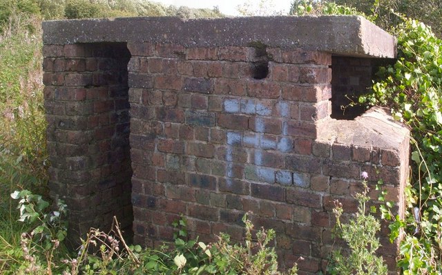
This structure, dating from the Second World War, was a minewatchers' post; during air raids, the personnel on duty here had to watch for mines that might be dropped by parachute into the River Clyde. Counting from east to west, it is the first of three such structures located on the shore between Bowling Outer Basin and the Erskine Bridge; for more information at Secret Scotland, see: Link (Archive Link )
The building is shown in context at NS4573 : Shore near Bowling Outer Basin. For the other two lookout posts, see Link (the second) and Link (the third). It is possible that there are others further upriver, but the shore there is occupied by various businesses, and is not readily accessible.
The structure was very cramped inside, with an internal height of about 1.8m; the internal space is about 1.7m square, but is further reduced by the fact that, at the right-hand side of the entrance, the outer wall turns and continues about halfway to the opposite wall, partially dividing the interior.
The brick walls are about 35cm thick, and the structure is topped with a concrete slab about 15cm high. The lookout slit itself can be seen to the right. Between the slit and the entrance, a much smaller hole is visible. This hole is inclined about 45 degrees from horizontal, and a portion of rusted pipe was still visible within it.
The second and third lookout buildings differ from the first, but are similar to each other; they both have two entrances (on the opposite side walls), and two shorter internal walls (one from beside each entrance); see the items on those buildings (links given above).
Minewatchers' posts, Bowling to Erskine :: NS4572
Second World War lookout posts, used when watching for parachute mines.
 Map © Crown Copyright")
TIP: Click the map for more Large scale mapping
- Grid Square
- NS4573, 252 images (more nearby 🔍)
- Photographer
- Lairich Rig (more nearby)
- Date Taken
- Friday, 4 September, 2009 (more nearby)
- Submitted
- Thursday, 10 September, 2009
- Subject Location
-
OSGB36:
 NS 4521 7337 [10m precision]
WGS84: 55:55.7046N 4:28.7461W - Camera Location
-
OSGB36: NS 4520 7337
- View Direction
- EAST (about 90 degrees)