2009
NS7968 : Stanrigg disaster memorial
taken 15 years ago, near to Plains, North Lanarkshire, Scotland
Stanrigg disaster memorial
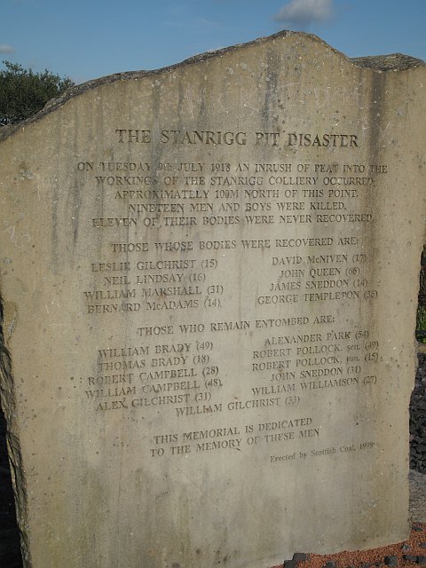
Memorial to 19 miners killed in a subsidence accident in July 1918. The seams were only about 20m below the surface, today the coalfield is surface mined, and there was an inrush of bog from the surface.
The memorial is hard to find now as it is no longer beside a road, the road being closed by opencast mining. Best way in is to walk from West Arbuckle. NS7968 : Closed road, West Arbuckle
The memorial is hard to find now as it is no longer beside a road, the road being closed by opencast mining. Best way in is to walk from West Arbuckle. NS7968 : Closed road, West Arbuckle
 Map © Crown Copyright")
TIP: Click the map for more Large scale mapping
- Grid Square
- NS7968, 38 images (more nearby 🔍)
- Photographer
- Richard Webb (more nearby)
- Date Taken
- Wednesday, 16 September, 2009 (more nearby)
- Submitted
- Tuesday, 22 September, 2009
- Subject Location
-
OSGB36:
 NS 796 682 [100m precision]
WGS84: 55:53.5262N 3:55.5873W - Camera Location
-
OSGB36: NS 796 682
- View Direction
- Northeast (about 45 degrees)