2009
SM8122 : Dinas Fawr and Pen Dinas (11)
taken 15 years ago, near to Solva, Pembrokeshire/Sir Benfro, Wales
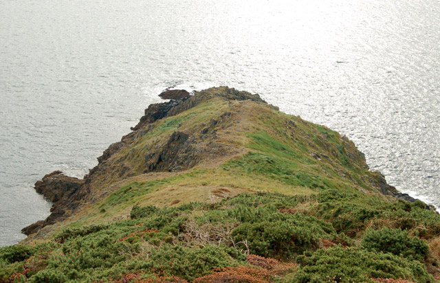
Dinas Fawr and Pen Dinas (11)
Looking south from the 'summit' to the very tip of Dinas Fawr headland. The photograph doesn't adequately convey the steepness of the slope: it is possible to get down to the rocky shore at the tip of the headland but it is a gruelling slog back up.
The dramatic heather-clad peninsula of Dinas Fawr is about a mile southeast of Solva, Pembrokeshire. The path to the headland is a public right of way. It leads from the long-distance coastpath along the knife-edge ridge to the tip of the headland. However, the path is exposed, rough-surfaced and precipitous so it is unsuitable for walkers who are not sure-footed and agile.
The dramatic heather-clad peninsula of Dinas Fawr is about a mile southeast of Solva, Pembrokeshire. The path to the headland is a public right of way. It leads from the long-distance coastpath along the knife-edge ridge to the tip of the headland. However, the path is exposed, rough-surfaced and precipitous so it is unsuitable for walkers who are not sure-footed and agile.
 Map © Crown Copyright")
TIP: Click the map for more Large scale mapping
- Grid Square
- SM8122, 20 images (more nearby 🔍)
- Photographer
- Andy F (more nearby)
- Date Taken
- Sunday, 27 September, 2009 (more nearby)
- Submitted
- Wednesday, 14 October, 2009
- Subject Location
-
OSGB36:
 SM 810 228 [100m precision]
WGS84: 51:51.6416N 5:10.9144W - Camera Location
-
OSGB36: SM 810 228
- View Direction
- Southwest (about 225 degrees)