2009
SD3097 : Ascent of Coniston Old Man (1)
taken 15 years ago, near to Coniston, Cumbria, England
Ascent of Coniston Old Man (1)
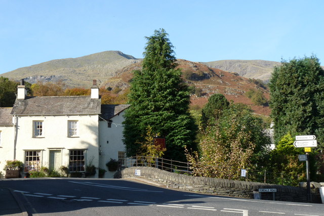
Alfred Wainwright (AW) describes the various ascents of The Old Man of Coniston, at 2633 feet, in his unique and thorough style; detailed both in text and drawings. Via Church Beck, AW quotes a distance of 2.5 miles, and 2450 feet of ascent. Very much the Tourist Route, and attempted by walkers of all abilities, the summit gives superb views on a clear day. With this series of photographs, I have attempted to show the route as it would be seen by the walker; looking initially towards the summit, but as the summit disappears from sight and the walker is faced with a steeper face of rock and meandering paths, some views back down the climb in the direction of Coniston.
I used the Coniston Tourist Information office as a start point, and have added the {camera} times for each photograph, as this information may be of interest to potential walkers who are not familiar with the route.
Having just left the Tourist Information office, The Old Man of Coniston can be seen on the skyline, to the left of picture. My route took me over the bridge and to the right, following the sign to the Sun Inn. Beyond the Sun Inn, the footpath is clearly marked. {11.19}.
Link
SD2997 : Ascent of Coniston Old Man (2)
 Map © Crown Copyright")
TIP: Click the map for more Large scale mapping
- Grid Square
- SD3097, 325 images (more nearby 🔍)
- Photographer
- Peter Trimming (more nearby)
- Date Taken
- Friday, 16 October, 2009 (more nearby)
- Submitted
- Sunday, 18 October, 2009
- Subject Location
-
OSGB36:
 SD 302 976 [100m precision]
WGS84: 54:22.1521N 3:4.5427W - Camera Location
-
OSGB36: SD 302 976
- View Direction
- WEST (about 270 degrees)