2009
SW4730 : Penzance railway station photo-survey (30)
taken 15 years ago, near to Penzance, Cornwall, England
Penzance railway station photo-survey (30)
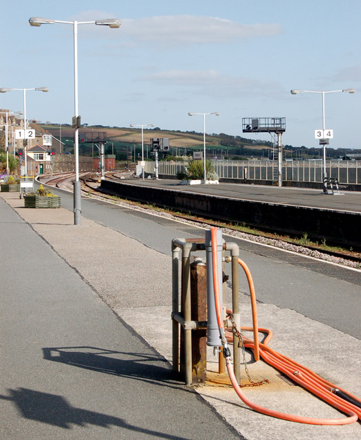
A water point serving platforms 1 and 2 at Penzance railway station, terminus of the former Great Western Railway's West of England mainline from London. The standpipe and hose are used to replenish the tanks of arriving trains - water is needed for the toilets, for washing facilities and for the buffet cars.
The original wooden station was opened by the West Cornwall Railway in 1852. The WCR was taken over by the GWR which constructed the current station which opened in 1879. Substantial improvements were made by the GWR in 1937. The station passed from the GWR to British Railways (Western Region) in 1948 when the railways were nationalised and is now operated by First Great Western. The current ticket office and buffet date from the 1980s.
The station stands beside the sea (partly on reclaimed land) and the main buildings are constructed of local stone. Platforms 1, 2 and 3 terminate inside a 'train shed' with an arched roof; however, platform 4 on the south side of the station is uncovered.
The extensive carpark and bus station southeast of the station were originally storage sidings and a large goods yard. One of the principal outbound traffics was fish from nearby Newlyn.
For earlier photos of Penzance with semaphore signals and locomotive-hauled trains see [Link] , [Link] , [Link] , [Link] and [Link] .
 Map © Crown Copyright")
TIP: Click the map for more Large scale mapping
- Grid Square
- SW4730, 940 images (more nearby 🔍)
- Photographer
- Andy F (more nearby)
- Date Taken
- Saturday, 17 October, 2009 (more nearby)
- Submitted
- Wednesday, 21 October, 2009
- Subject Location
-
OSGB36:
 SW 476 306 [100m precision]
WGS84: 50:7.3291N 5:31.9124W - Camera Location
-
OSGB36: SW 476 306
- View Direction
- Northeast (about 45 degrees)