2009
NZ2888 : Woodhorn Colliery
taken 14 years ago, near to Woodhorn, Northumberland, England
This is 1 of 3 images, with title Woodhorn Colliery in this square
Woodhorn Colliery
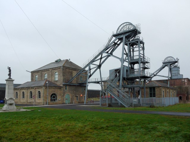
The memorial to 13 killed in a single explosion in 1916 is visible on the left NZ2888 : Memorial and pit head, Woodhorn
The wheel at the front is known as No 1 Heapstead (a term referring to buildings around a colliery shaft), with its Winding House on the left, built of yellow bricks from clay removed from the mine shafts. These structures date from 1897 although the pit wheels and headgear were replaced in 1972. The second headgear structure to the rear, right, serviced the upcast mine shaft.
The wheel at the front is known as No 1 Heapstead (a term referring to buildings around a colliery shaft), with its Winding House on the left, built of yellow bricks from clay removed from the mine shafts. These structures date from 1897 although the pit wheels and headgear were replaced in 1972. The second headgear structure to the rear, right, serviced the upcast mine shaft.
Woodhorn Colliery
Woodhorn Colliery operated from 1894 to 1981. The number of fatalities over all the years of mining was more than 102 with 13 killed in an explosion in 1916 Link
The colliery was reopened as a museum in 1989 and is considered to be the best surviving example of a late 19th to early 20th century colliery from the North East England regional tradition. The site is of national significance, and an important monument to the Northumberland coal industry Link
A new building on the site, 'The Cutter' provides an interpretation centre and houses the Northumberland County archives. There is also a café, shop and exhibition space.
A link to the Woodhorn Colliery web site is here Link
 Map © Crown Copyright")
TIP: Click the map for more Large scale mapping
- Grid Square
- NZ2888, 76 images (more nearby 🔍)
- Photographer
- Andrew Curtis (more nearby)
- Date Taken
- Saturday, 21 November, 2009 (more nearby)
- Submitted
- Saturday, 21 November, 2009
- Subject Location
-
OSGB36:
 NZ 2888 8841 [10m precision]
WGS84: 55:11.3479N 1:32.8767W - Camera Location
-
OSGB36: NZ 2880 8838
- View Direction
- East-northeast (about 67 degrees)