1989
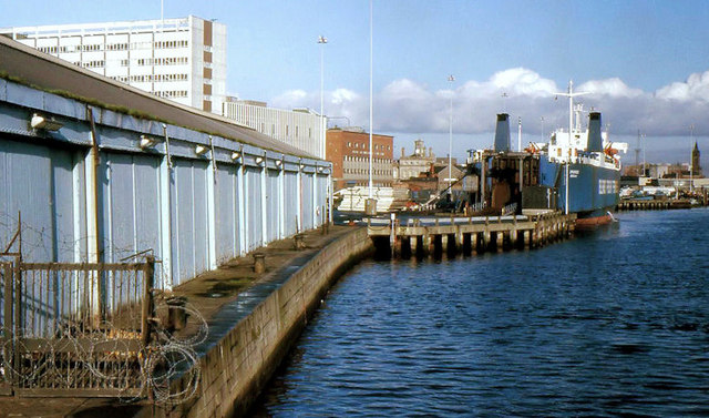
J3474 : The Heysham shed, Belfast
taken 34 years ago, near to Belfast, Co Antrim, Northern Ireland
The Heysham shed, Belfast
The Heysham shed (left), at Donegall Quay was used, in the days before ro-ro ferries, to handle general cargo to and from the Heysham boat. J3474 : Donegall Quay, Belfast (2007) shows how the quay was initially redeveloped and J3474 : The "Obel" site, Belfast (97) shows a more recent view with The Obel being built on a site just beyond the ferry berth.
Building the Lagan weir and cross-harbour bridges, Belfast
A collection of photographs showing the building of the Lagan weir and the cross-harbour road and railway bridges in the early 1990s. There are also some earlier shots of the pre-impounding River Lagan, of Donegall and Queens Quays, the Abercorn Basin and of the immediate area before demolition.
Loading map... (JavaScript required)
- Grid Square
- J3474, 4349 images (more nearby 🔍)
- Photographer
- Albert Bridge (more nearby)
- Date Taken
- Saturday, 25 November, 1989 (more nearby)
- Submitted
- Monday, 4 January, 2010
- Subject Location
-
Irish:
 J 344 744 [100m precision]
WGS84: 54:36.0403N 5:55.2649W - Camera Location
-
Irish: J 344 744
- View Direction
- North-northwest (about 337 degrees)