2003
SC1867 : Mull Hill - Mull or Meayll Circle burial site
taken 21 years ago, near to Cregneash, Isle of Man
This is 1 of 8 images, with title Mull Hill - Mull or Meayll Circle burial site in this square
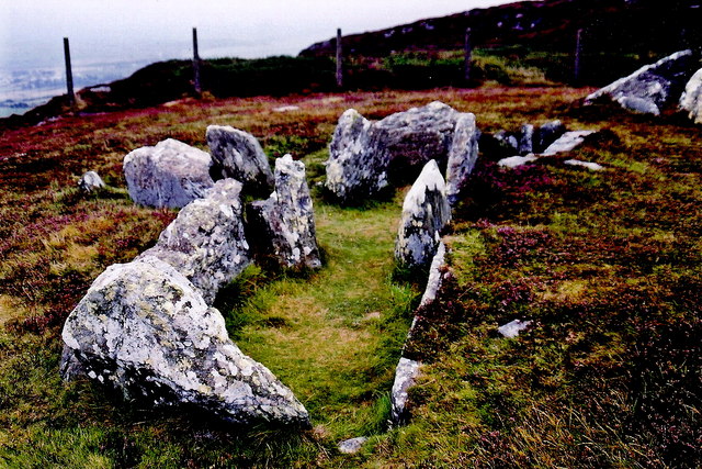
Mull Hill - Mull or Meayll Circle burial site
The burial site is located up a steep hill east from Ballnahowe Road where a marker is posted. It took some effort to climb the hill and climb over the fence at the top. The marker reads:
The Mull Circle
Prehistoric burial of late neolithic or early bronze age.
Circle of cists in six pairs with passage between each pair radiating outwards. View is to the north.
The Mull Circle
Prehistoric burial of late neolithic or early bronze age.
Circle of cists in six pairs with passage between each pair radiating outwards. View is to the north.
 Map © Crown Copyright")
TIP: Click the map for more Large scale mapping
- Grid Square
- SC1867, 279 images (more nearby 🔍)
- Photographer
- Joseph Mischyshyn (more nearby)
- Date Taken
- Tuesday, 16 September, 2003 (more nearby)
- Submitted
- Tuesday, 2 February, 2010
- Subject Location
-
OSGB36:
 SC 189 677 [100m precision]
WGS84: 54:4.4419N 4:46.1306W - Camera Location
-
OSGB36: SC 189 677
- View Direction
- NORTH (about 0 degrees)