2010
TQ3778 : Launch site of SS Great Eastern, Isle of Dogs
taken 14 years ago, near to Isle of Dogs, Tower Hamlets, England
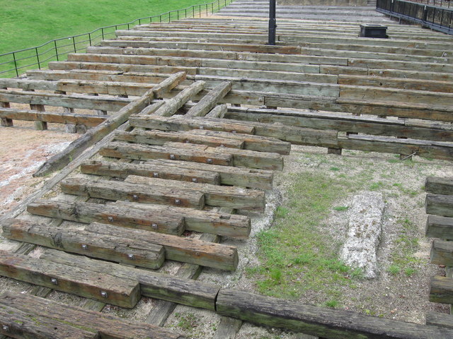
Launch site of SS Great Eastern, Isle of Dogs
These old timbers are what remains of the slipway from which was launched Brunel's ambitious but ill fated creation, the "SS Great Eastern". She was the first double skinned iron hulled ship to be built, the first to have steam powering paddle wheels as well as a propeller, and had six sail carrying masts as a back up. It was envisaged that with this combination she would sail round the world without refuelling. At a displacement of 32,000 tons, she was destined to be the largest ship for another forty one years.
Her huge size was to present enormous problems at the launch. Couldn't go stern first as she would have hit the far bank of the river. So a sideways launch was chosen. But again, her size and weight was too much and defeated the steam powered rams which were to push her broadside into the water. Only after the thirteenth attempt did they finally achieve success on the 31st of January 1858.
After fitting out, and on her maiden voyage her engine blew up, killing five stokers and one more who panicked and jumped overboard and was lost.
She did however complete several transatlantic crossings, mostly as a cable layer.
But alas, she proved to be far too costly to operate and was finally broken up in 1889. For a picture of the restraining chains used at the launch, see TQ3778 : Chains used at the launch of SS Great Eastern
 Map © Crown Copyright")
TIP: Click the map for more Large scale mapping
- Grid Square
- TQ3778, 313 images (more nearby 🔍)
- Photographer
- Derek Voller (more nearby)
- Date Taken
- Wednesday, 14 April, 2010 (more nearby)
- Submitted
- Wednesday, 14 April, 2010
- Subject Location
-
OSGB36:
 TQ 375 784 [100m precision]
WGS84: 51:29.2810N 0:1.2500W - Camera Location
-
OSGB36: TQ 374 783
- View Direction
- Northeast (about 45 degrees)