2010
NY9443 : National Cycle Network milepost on the Boltslaw Incline
taken 14 years ago, near to Rookhope, County Durham, England
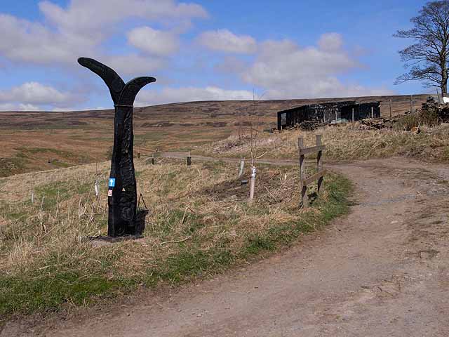
National Cycle Network milepost on the Boltslaw Incline
With a length of 225 Km, The C2C Link (coast to coast) cycleway (National Cycle Network route 7) is Britain's best known cycleway and is completed by tens of thousands of cyclists every year.
The National Cycle Network is marked at intervals by specially designed mileposts donated to the project by the Royal Bank of Scotland. There are four designs - one each by an Englishman, a Welshman, a Scotsman and an Irishman. This example at the foot of the notorious Boltslaw Incline is an "English" one, entitled "the Fossil Tree" and designed by John Mills. Link (Archive Link ) .
The National Cycle Network is marked at intervals by specially designed mileposts donated to the project by the Royal Bank of Scotland. There are four designs - one each by an Englishman, a Welshman, a Scotsman and an Irishman. This example at the foot of the notorious Boltslaw Incline is an "English" one, entitled "the Fossil Tree" and designed by John Mills. Link
 Map © Crown Copyright")
TIP: Click the map for more Large scale mapping
- Grid Square
- NY9443, 71 images (more nearby 🔍)
- Photographer
- Oliver Dixon (more nearby)
- Date Taken
- Wednesday, 14 April, 2010 (more nearby)
- Submitted
- Friday, 16 April, 2010
- Subject Location
-
OSGB36:
 NY 940 432 [100m precision]
WGS84: 54:47.0362N 2:5.6143W - Camera Location
-
OSGB36: NY 940 432
- View Direction
- North-northwest (about 337 degrees)