2010
TG3602 : Langley - remains of the abbey
taken 14 years ago, near to Langley Street, Norfolk, England
This is 1 of 24 images, with title Langley - remains of the abbey in this square
Langley - remains of the abbey
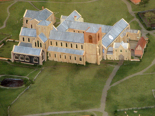
This model of Langley Abbey, as it is thought to have looked like, is on exhibit in the great hall > Link.
With restoration work completed what remains of the abbey is now open to the public. For a fee of £4 it is possible to view the former great hall, the abbot's private chamber as well as the vaulted cellarium below. The remains of the ruined abbey church, situated in the paddock to the east of the complex, can be explored by pre-booked guided tours only.
Langley, a Premonstratensian abbey, was founded in 1195 and dissolved in 1536. The buildings were surrounded by a wet ditch which had three entrances. Some of the buildings are still standing and are included in the present farm buildings. Excavations in 1921 revealed that the cruciform church had a tower at the West end. The presbytery was flanked by chapels extending east from the transepts, and an additional chapel to the north of the north transept. The claustral buildings were arranged to the south and included the sacristy, chapter house, parlour, dorter and its sub-vault and a warming house in the east range, the frater in the south range, and cellarium in the west range. A gatehouse adjoined the north part of the cellarium. The stable, part of the gatehouse, the cellarium with its vaulted undercroft to the north, parts of the west and north walls of the Chapter House and the south-east corner of the infirmary can all still be seen.
 Map © Crown Copyright")
TIP: Click the map for more Large scale mapping
- Grid Square
- TG3602, 131 images (more nearby 🔍)
- Photographer
- Evelyn Simak (more nearby)
- Date Taken
- Tuesday, 6 July, 2010 (more nearby)
- Submitted
- Tuesday, 6 July, 2010
- Subject Location
-
OSGB36:
 TG 361 028 [100m precision]
WGS84: 52:34.3343N 1:29.0463E - Camera Location
-
OSGB36: TG 361 028
- View Direction
- Southeast (about 135 degrees)