2010
SS9629 : Exmoor : Wimbleball Dam
taken 14 years ago, 3 km from Brompton Regis, Somerset, England
This is 1 of 27 images, with title Exmoor : Wimbleball Dam in this square
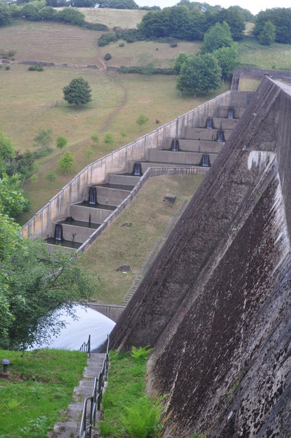
Exmoor : Wimbleball Dam
The 161 feet (49 m) high dam is of concrete buttress construction and impounds the River Haddeo to provide a water storage capacity of some 21,000 megalitres over an area of 374 acres (0.584 sq mi). Aggregate for the dam came from a quarry at Bampton and sand from Cullompton. These were combined to give a pinkish tinge to blend in with the local geology.
 Map © Crown Copyright")
TIP: Click the map for more Large scale mapping
- Grid Square
- SS9629, 150 images (more nearby 🔍)
- Photographer
- Lewis Clarke (more nearby)
- Date Taken
- Saturday, 10 July, 2010 (more nearby)
- Submitted
- Tuesday, 13 July, 2010
- Subject Location
-
OSGB36:
 SS 964 292 [100m precision]
WGS84: 51:3.1882N 3:28.7319W - Camera Location
-
OSGB36: SS 964 292
- View Direction
- North-northeast (about 22 degrees)