2006
TQ0878 : Hayes: Sam Philps Community Woodland & Recreation Ground
taken 18 years ago, near to Sipson, Hillingdon, England
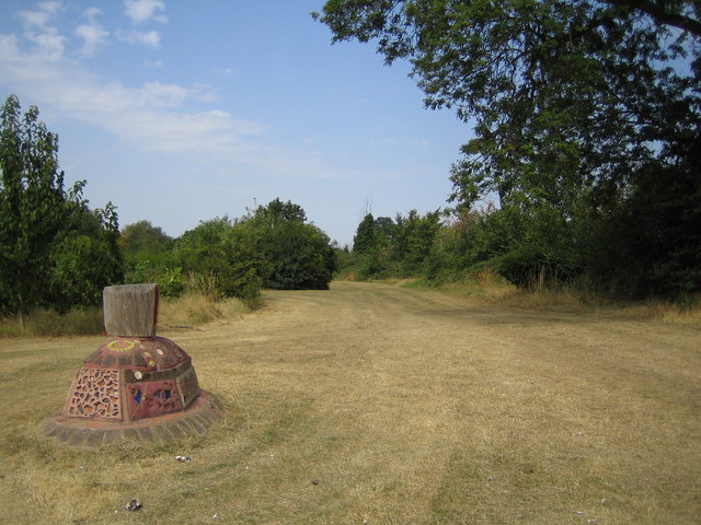
Hayes: Sam Philps Community Woodland & Recreation Ground
This area was once an under-utilised park next to Shepiston Lane and the M4 Motorway, but in 2001 it was planted with more than 5,000 native trees and shrubs by the then Trees for London organization, (now Trees for Cities), as a pollution barrier between this busy road and the residential area next to it, which includes two schools and a community centre. Mosaic sculptures, such as the one in the image, have also been installed at the site, and were designed by community artist Friedel Buecking, with the help of local school children. The Trees for Cities website is here Link (Archive Link )
(Incidentally there is an extraordinary amount of confusion about the surname of the person after whom the area is named. I have used Philps as it is shown on the plaques on the mosaics, and on the Trees for London website, but Hillingdon Council use Phelp, Philp and Philps on different pages on their website, Hillingdon Business Education Partnership use Phelps, Streetmap use Philip, the London Assembly have Phelps, Philip and Philps, the Ordnance Survey have Philp, and the Hillingdon Times have Philips.)
Update, January 2008: A visitor to the site has e-mailed me to ask me if I am aware that this area was/is always referred to locally as The Bunny Fields or The Bunnies. She says "I lived about 10 mins walk away from The Bunnies from my birth in 1966 on and off until 1989, and went to Pinkwell Primary and Harlington Secondary Schools - both practically next to The Bunnies. For 5 of those years I walked my dog there practically every single day, and the fields were an incredibly important place in my childhood and teen years. I just think this name for the fields should be recorded by your project - I never once heard the area referred to as Sam Phelps - EVERYONE called it The Bunny Fields! (Though I never once saw a rabbit there - only water rats!)"
 Map © Crown Copyright")
TIP: Click the map for more Large scale mapping
- Grid Square
- TQ0878, 71 images (more nearby 🔍)
- Photographer
- Nigel Cox (more nearby)
- Date Taken
- Thursday, 20 July, 2006 (more nearby)
- Submitted
- Sunday, 23 July, 2006
- Subject Location
-
OSGB36:
 TQ 087 784 [100m precision]
WGS84: 51:29.6462N 0:26.1361W - View Direction
- WEST (about 270 degrees)