2010
TM4874 : St Andrew's church in Walberswick
taken 14 years ago, near to Walberswick, Suffolk, England
This is 1 of 3 images, with title St Andrew's church in Walberswick in this square
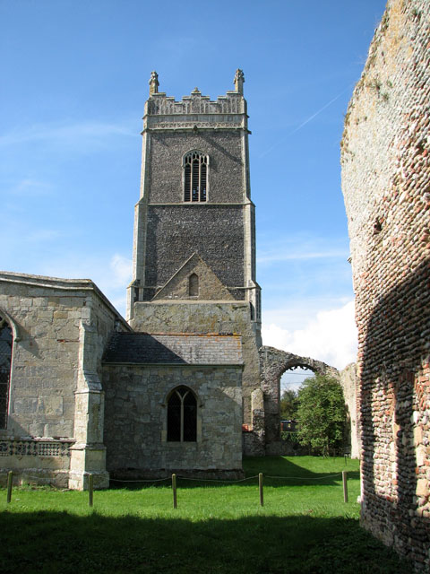
St Andrew's church in Walberswick
An older church which stood on the site was taken down in the late 14th century and a new church built on the same spot. St Andrew's church was dedicated in 1493. It was a large building, built onto the tower of the old church and it contained a side chapel and four altars. The nave and chancel had 18 clerestory windows on each side. The church prospered until tithes were stopped being paid in 1538. Subsequently the church and, in fact, the whole town became very poor. Very little was done to repair the church in the following decade. In 1695 permission was obtained to unroof nave, chancel > Link and north aisle and to sell the materials, including three of the four remaining bells, with the proceeds going towards the repair of the south aisle which still houses the current church. When the surrounding ruins were excavated in 1930 a quantity of 14th and 15th century stained glass, all in fragments, was found and many of these fragments were assembled into one light of a window > Link on the south wall. The south porch > Link has survived in its original state and is a good example of the original splendour of the church, as it looked in the 15th century. The elaborately carved pulpit > Link and the baptismal font > Link are also 15th century. The ruined east end of the church is divided from the west end by a grid line that runs through it, placing the church into two different grid squares.
 Map © Crown Copyright")
TIP: Click the map for more Large scale mapping
- Grid Square
- TM4874, 139 images (more nearby 🔍)
- Photographer
- Evelyn Simak (more nearby)
- Date Taken
- Tuesday, 21 September, 2010 (more nearby)
- Submitted
- Wednesday, 22 September, 2010
- Subject Location
-
OSGB36:
 TM 4896 7476 [10m precision]
WGS84: 52:18.8667N 1:39.0732E - Camera Location
-
OSGB36: TM 4900 7476
- View Direction
- WEST (about 270 degrees)