J3575 : The Titanic Signature Project, Belfast (14)
taken 13 years ago, near to Belfast, Co Antrim, Northern Ireland
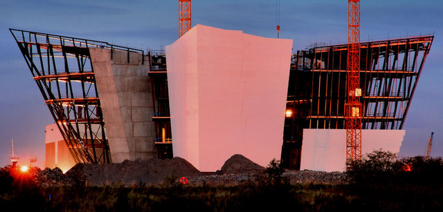
Work started, in May 2009, on what, at the time, was known as The Titanic Signature Project. The building opened to the public on 31 March 2012. This is a series of photographs showing the construction work underway and after the public opening. It is owned by an independent charitable trust known as Titanic Foundation Limited Link
.
The site occupies some 75 acres of waterfront, former industrial land on the eastern side of the River Lagan in the Titanic Quarter and close to the centre of Belfast. The architects were Todd Architects who designed J3372 : Department of Architecture, Queen's University, Belfast (2) and J3474 : The "Boat" site, Belfast (42).
Not a proper quay in that it has no face capable of handling ships. Previously known as the Queens Island Wharf (western side). Its southern end faces the Abercorn Basin. Due for (eventual) re-development as part of the Titanic Quarter.
A selection of photographs showing some of the buildings and the undeveloped sites in the Titanic Quarter, Belfast. The area includes 185 acres of the former Harland & Wolff shipyard. The new buildings cover a range of uses including apartments, offices, hotel, a college, the Public Record Office for Northern Ireland and the Titanic Belfast.
- Grid Square
- J3575, 1038 images (more nearby 🔍)
- Photographer
- Albert Bridge (more nearby)
- Date Taken
- Thursday, 21 October, 2010 (more nearby)
- Submitted
- Thursday, 21 October, 2010
- Subject Location
-
Irish:
 J 351 752 [100m precision]
WGS84: 54:36.4545N 5:54.5844W - Camera Location
-
Irish: J 348 749
- View Direction
- Northeast (about 45 degrees)