2010
NZ0312 : Rutherford gauging weir on the River Greta, low water
taken 14 years ago, near to Boldron, County Durham, England
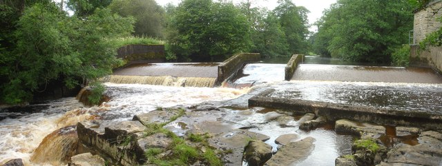
Rutherford gauging weir on the River Greta, low water
Seen here at just under 0.4m on the gauge which is well below a paddleable level, Rutherford gauging weir is incredibly useful to canoeists as the Environment Agency make recent level data available online. Unfortunately, not at a stable URL, so finding it will involve a search engine. Past flows can be seen at the National River Flow Archive Link (Archive Link ) . With a longish catchment spread over 86 square kilometres, it's not quite a spate beck, but does nonetheless rise and fall quite quickly so it's one of those rivers that tend to get paddled at short notice - often when your planned trip has too much water. The river comes into condition (and can be paddled from the Gilmonby bridge in Bowes) at about 0.55m, though another 10cm helps. At that level (as seen in NZ0312 : Rutherford Gauging Weir it is about 0.53m) the easiest line is river left, then cutting back right. With more water, that line can be continued pretty much over where the photographer was standing for this shot. Braver souls can take the river right line, which has a bigger stopper and some low overhanging branches. The central chute is best avoided, and often encumbered with washed down branches. The river starts to get a bit pushy with the gauge over 1m - 1.2m is the highest I've paddled NZ0812 : Hell Cauldron, River Greta, and that was starting to get a bit scary as the river is prone to tree hazard in the sort of weather that produces those levels.
 Map © Crown Copyright")
TIP: Click the map for more Large scale mapping
- Grid Square
- NZ0312, 26 images (more nearby 🔍)
- Photographer
- Andy Waddington (more nearby)
- Date Taken
- Thursday, 15 July, 2010 (more nearby)
- Submitted
- Saturday, 13 November, 2010
- Subject Location
-
OSGB36:
 NZ 0335 1219 [10m precision]
WGS84: 54:30.3010N 1:56.9867W - Camera Location
-
OSGB36: NZ 0337 1218
- View Direction
- West-northwest (about 292 degrees)