1979
SJ8498 : Woolworth's, Manchester
taken 45 years ago, near to Manchester, England
Woolworth's, Manchester
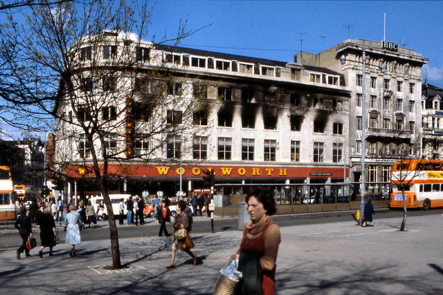
The Woolworth's department store at the corner of Oldham Street and Piccadilly in Manchester, photographed a few days after the disastrous fire of 8th May 1979 which killed 10 people and left a further 47 needing hospital treatment.
The store comprised six floors along with two basement levels and at the time was said to be the largest Woolworth store in Europe. Crucially, the store had no sprinkler system fitted. It is believed that the fire was started by a damaged electrical cable that had furniture stacked in front of it.
The disaster led to a major shake-up in UK fire laws after it was revealed that polyurethane foam fillings in furniture at the store made the situation much worse. The foam would burn rapidly, producing large amounts of thick dense smoke which would have soon obscured the exit signs. This would have led to confusion and, together with the irritants in the smoke affecting peoples vision and causing breathing difficulties, would have hindered any escape. The changes in legislation are believed to have saved thousands of lives since.
At the time, on 8 May 1979, the Woolworth store blaze was the city's worst fire disaster since World War II.
Link Fatal city store fire remembered (BBC News)
Link (Archive Link ) (UK Fire Service report)
The store comprised six floors along with two basement levels and at the time was said to be the largest Woolworth store in Europe. Crucially, the store had no sprinkler system fitted. It is believed that the fire was started by a damaged electrical cable that had furniture stacked in front of it.
The disaster led to a major shake-up in UK fire laws after it was revealed that polyurethane foam fillings in furniture at the store made the situation much worse. The foam would burn rapidly, producing large amounts of thick dense smoke which would have soon obscured the exit signs. This would have led to confusion and, together with the irritants in the smoke affecting peoples vision and causing breathing difficulties, would have hindered any escape. The changes in legislation are believed to have saved thousands of lives since.
At the time, on 8 May 1979, the Woolworth store blaze was the city's worst fire disaster since World War II.
Link
Link
 Map © Crown Copyright")
TIP: Click the map for more Large scale mapping
- Grid Square
- SJ8498, 3904 images (more nearby 🔍)
- Photographer
- David Dixon (more nearby)
- Date Taken
- Saturday, 12 May, 1979 (more nearby)
- Submitted
- Wednesday, 1 December, 2010
- Subject Location
-
OSGB36:
 SJ 8439 9833 [10m precision]
WGS84: 53:28.8874N 2:14.2013W - Camera Location
-
OSGB36: SJ 8437 9831
- View Direction
- Northeast (about 45 degrees)