2011
SE7724 : The Triangle
taken 13 years ago, near to Skelton, East Riding of Yorkshire, England
The Triangle
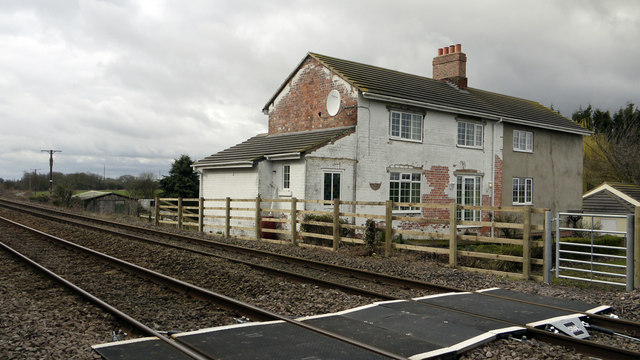
The Triangle is a single home created from two former railway cottages at the railwayside between Goole and Hull. It's not apparent from OS maps at either 1:25 000 or 1:50 000 scales that a public right of way exists passing the cottage and crossing the railway but the footway over the track can be seen in the photograph. The house owner tells that recent work (Feb. 2011) has been done on behalf of Network Rail at the crossing; new equipment can be seen there, possibly safety related. The Triangle bears an OS. flush bracket - No. 2207.
 Map © Crown Copyright")
TIP: Click the map for more Large scale mapping
- Grid Square
- SE7724, 20 images (more nearby 🔍)
- Photographer
- Trevor Littlewood (more nearby)
- Date Taken
- Sunday, 27 February, 2011 (more nearby)
- Submitted
- Monday, 28 February, 2011
- Subject Location
-
OSGB36:
 SE 775 249 [100m precision]
WGS84: 53:42.9131N 0:49.6124W - Camera Location
-
OSGB36: SE 775 249
- View Direction
- Northwest (about 315 degrees)