2011
NS4660 : Gleniffer Braes Country Park
taken 13 years ago, near to Glenburn, Renfrewshire, Scotland
This is 1 of 3 images, with title Gleniffer Braes Country Park in this square
Gleniffer Braes Country Park
The path leads towards a small group of trees, near which there is a NS4660 : Footbridge over the Gleniffer Burn (that group of trees can be seen in both pictures).
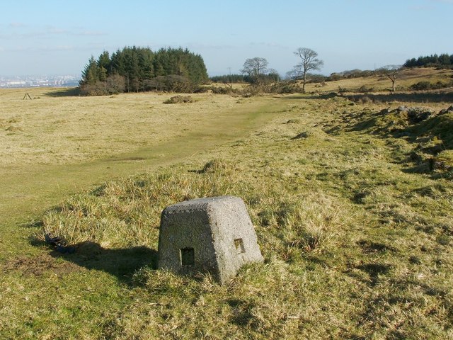
Visible on the right, in the present photograph, are the low remains of a dry-stone wall; that boundary is shown on the first-edition OS map (1858). This area lies to the south of the main network of paths in the park.
The object in the foreground is not very large; the picture was taken from a low viewpoint in order to show it clearly. The flat part of its top is 27cm square. I was not looking out for them, but noticed three such markers in the area; there are probably more.
I had originally taken them to be orienteering markers, but I am told that they were most probably located here in connection with the nearby reservoirs, and that it is not unusual to find, in such settings, markers that are unlike the standard OS ones (I am grateful to Fasgadh for this information). See also the comments at SK9408 : Not a trig point.
 Map © Crown Copyright")
TIP: Click the map for more Large scale mapping
- Grid Square
- NS4660, 67 images (more nearby 🔍)
- Photographer
- Lairich Rig (more nearby)
- Date Taken
- Monday, 28 February, 2011 (more nearby)
- Submitted
- Thursday, 17 March, 2011
- Subject Location
-
OSGB36:
 NS 4628 6035 [10m precision]
WGS84: 55:48.7127N 4:27.2763W - Camera Location
-
OSGB36: NS 4622 6034
- View Direction
- EAST (about 90 degrees)