2011
TQ2652 : Reigate Hill Footbridge
taken 13 years ago, near to Reigate, Surrey, England
This is 1 of 12 images, with title Reigate Hill Footbridge in this square
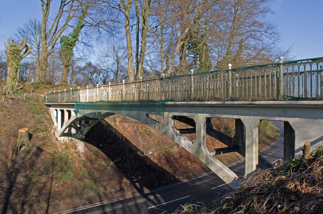
Reigate Hill Footbridge
The original main road north out of Reigate, on what was then the main Brighton to London turnpike, crested the North Downs ridge via what is now Reigate Hill car park, the route rejoining the current road at what is now the junction with Gatton Bottom and Wray Lane.
In 1824, in order to ease the final hill and bend, a cutting was dug into the crest of the hill, severing the trackway that followed the ridge. An iron suspension bridge was carried across the cutting, to a design of William Constable, who the previous year had also built Reigate Tunnel, with the same purpose of easing the route to Brighton (see TQ2550 : Reigate Tunnel). The bridge was opened in 1825.
However, it eventually became unsafe and was replaced in 1910 by a reinforced concrete arch to a design by L G Mouchel and Partners, the pioneers of the use of reinforced concrete in the UK. It has a 97 foot span and weighs only 3 tons, the low weight being due to the narrowness of the beams enabled by the new technique.
It is notable as the earliest concrete footbridge in the country, and in recognition of this in 2002 it was listed as a grade II structure - for listing particulars see Link .
.
The track carried by the bridge now forms part of the North Downs Way.
This particular view has only recently become possible - some tree felling has taken place to the south of the bridge with a view to installing a temporary replacement while the original structure is refurbished in the summer of 2011.
In 1824, in order to ease the final hill and bend, a cutting was dug into the crest of the hill, severing the trackway that followed the ridge. An iron suspension bridge was carried across the cutting, to a design of William Constable, who the previous year had also built Reigate Tunnel, with the same purpose of easing the route to Brighton (see TQ2550 : Reigate Tunnel). The bridge was opened in 1825.
However, it eventually became unsafe and was replaced in 1910 by a reinforced concrete arch to a design by L G Mouchel and Partners, the pioneers of the use of reinforced concrete in the UK. It has a 97 foot span and weighs only 3 tons, the low weight being due to the narrowness of the beams enabled by the new technique.
It is notable as the earliest concrete footbridge in the country, and in recognition of this in 2002 it was listed as a grade II structure - for listing particulars see Link
The track carried by the bridge now forms part of the North Downs Way.
This particular view has only recently become possible - some tree felling has taken place to the south of the bridge with a view to installing a temporary replacement while the original structure is refurbished in the summer of 2011.
 Map © Crown Copyright")
TIP: Click the map for more Large scale mapping
- Grid Square
- TQ2652, 137 images (more nearby 🔍)
- Photographer
- Ian Capper (more nearby)
- Date Taken
- Saturday, 19 March, 2011 (more nearby)
- Submitted
- Tuesday, 22 March, 2011
- Subject Location
-
OSGB36:
 TQ 262 523 [100m precision]
WGS84: 51:15.3618N 0:11.5629W - Camera Location
-
OSGB36: TQ 262 523
- View Direction
- West-northwest (about 292 degrees)