2011
SU8091 : Lane End: Holy Trinity Church
taken 13 years ago, near to Lane End, Buckinghamshire, England
This is 1 of 2 images, with title Lane End: Holy Trinity Church in this square
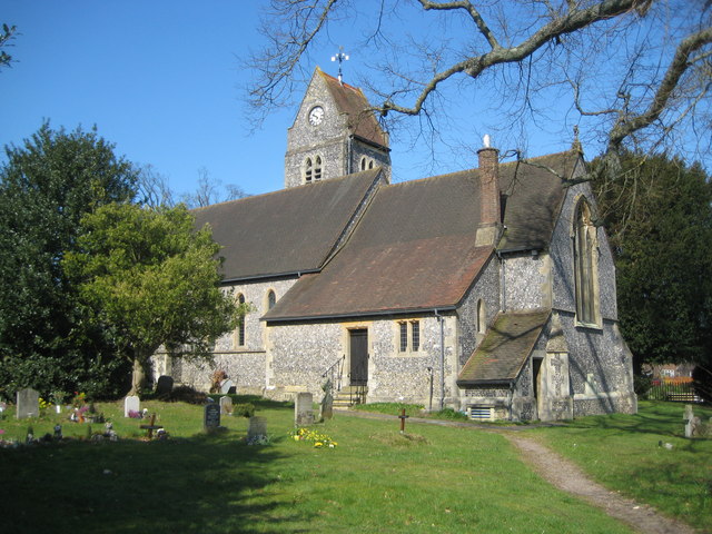
Lane End: Holy Trinity Church
The church is a Grade II Listed Building although it was only built in 1877 replacing a short-lived earlier church. By a coincidence the earliest edition of the large scale Ordnance Survey map currently available online does date from 1877 and shows the footprint of the earlier church, whose long axis was orientated north-south rather than the east-west configuration of the present-day building.
The English Heritage Listed Buildings website describes it thus:-
"Parish church. Dated 1877 on stone dedication tablet at E. end. By J. Oldrid Scott. Flint with stone dressings, tiled roofs. Nave, N. porch, tower in angle with small N. transept, N. chapel, chancel and S, vestry. In Early English style with lancet windows. Off-set buttresses, stone sill course, flint and stone chequer patterning to tops of gables. Nave has 2 lancets and cusped roundel to W., 5 lancets to S. with arched door to left, and 2 lancets to N. Gabled N. porch at right end, with double chamfered arch, and paired cusped lights to each side. Tower, raised 1901, is of 3 stages with saddle-back roof, clocks in gables, paired cusped openings to bell-chamber, lancets, and W. door. Triple lancets in small gable of N. transept, the central light taller. N. chapel has 3 lancets to N. and traceried roundel to E. Chancel has 3-light traceried E. window with carved head hoodmould stops. Door and 2-light window to vestry. Interior: nave has 6-bay roof of re-used medieval timbers from barn at Bisham Abbey, with chamfered arch-braces to collars, and chamfered arched wind-braces."
 Map © Crown Copyright")
TIP: Click the map for more Large scale mapping
- Grid Square
- SU8091, 50 images (more nearby 🔍)
- Photographer
- Nigel Cox (more nearby)
- Date Taken
- Saturday, 19 March, 2011 (more nearby)
- Submitted
- Saturday, 26 March, 2011
- Subject Location
-
OSGB36:
 SU 806 916 [100m precision]
WGS84: 51:37.0693N 0:50.2169W - Camera Location
-
OSGB36: SU 806 916
- View Direction
- North-northwest (about 337 degrees)