1991
J3474 : Weir and cross-harbour links, Belfast (19)
taken 32 years ago, near to Belfast, Co Antrim, Northern Ireland
Weir and cross-harbour links, Belfast (19)
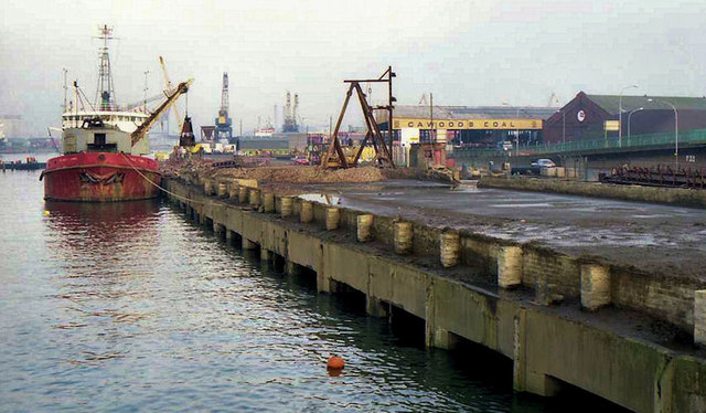
See J3474 : Weir and cross-harbour links, Belfast (18). The view, downstream, from the Queen Elizabeth Bridge. The dredger Hebble Sand is discharging silt into the temporary compound at Queens Quay (right). The silt was removed by lorry, for disposal. Continue to J3474 : Weir and cross-harbour links, Belfast (20).
Building the Lagan weir and cross-harbour bridges, Belfast
A collection of photographs showing the building of the Lagan weir and the cross-harbour road and railway bridges in the early 1990s. There are also some earlier shots of the pre-impounding River Lagan, of Donegall and Queens Quays, the Abercorn Basin and of the immediate area before demolition.
Loading map... (JavaScript required)
- Grid Square
- J3474, 4349 images (more nearby 🔍)
- Photographer
- Albert Bridge (more nearby)
- Date Taken
- Saturday, 7 December, 1991 (more nearby)
- Submitted
- Tuesday, 5 April, 2011
- Subject Location
-
Irish:
 J 345 744 [100m precision]
WGS84: 54:36.0434N 5:55.1347W - Camera Location
-
Irish: J 345 744
- View Direction
- Northeast (about 45 degrees)