What happens in grid square
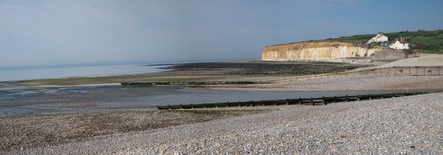
TV5197, over the next few years, will have crucial consequences for the lower part of the Cuckmere valley. The water dynamics of the estuary, at present, allow for the flow of river water to drain to the sea while at the same time allowing the tidal flow of water into the mouth and estuary of the river Cuckmere. This system has been maintained by active water management at and near the mouth of the river. In addition to keeping the mouth of the river open, there are a variety of coastal and river management schemes involving the maintenance of protective features including a sea wall beneath the coastguard cottages, rock armour, metal piles, wooden groynes, revetments and levees. In addition to this, there are perpetual tasks such as beach recharging, recycling of pebbles from the river mouth and beach reprofiling to be done. With all this investment and effort in recent years, to protect the gateway to the Cuckmere valley, it is easy to appreciate the Cuckmere Estuary Partnerships vision of restoring the area to that of a naturally functioning and self-sustaining estuary without the need for the control given by hard engineering projects. This view of a sustainably managed future contrasts sharply with that which sanctioned sand and gravel extraction from the Cuckmere Haven beach between the early 1930s to 1964. This was on such a scale that a 2 foot (609.6mm) gauge railway was built to take the sand and gravel from the beach to a depot where the car park at Exceat now stands.
In historical times, the flow of the River Cuckmere entered the English Channel at different points. In 1587 and 1873, for example, the river entered the sea near Cliff End on the eastern side ; in 1724 and 1778, the river mouth was at a mid-way point on Cuckmere Haven beach, while in 1757, the mouth was close to the cliffs at South Hill on the western side. Until recently, the waters of the River Cuckmere entered the sea at a point to the west of centre on Cuckmere Haven beach and this point had been largely fixed by physical engineering in the form of piles, revetments and wooden training walls. However, during the first week of April 2014, the river mouth shifted westwards to a new location further along the beach and in the direction of the coastguard cottages. An extensive area of new beach has formed near the mouth of the river and this probably results from longshore drift transporting flint pebbles along the coast from the direction of Seaford and depositing them there. In former times, the mouth of the river would become choked by shingle swept along the coast by longshore drift. Flint pebbles were deposited as a spit or bar at the mouth of the river. At one time, local farmers would use a horse and plough to open a channel through the shingle and allow the river to flow to the sea. This action helped to prevent floods near the mouth and further up the valley. In recent times, the Environment Agency has been dredging the mouth of the river twice a year to create a steeper gradient and thereby allow the free flow of water. The flint pebbles dredged from the mouth of the river are recycled on the beach. Although this recycling of pebbles is a relatively cheap method of beach augmentation, the total operation is still costly. In line with Government policy for sparsely populated areas, the flood prevention measures are not to be maintained.
The appearance of the River Cuckmeres floodplain and one of its present principal land uses of farming are made possible by the coastal defences and management at the mouth of the river. Although this management of the area has been in place for many years, the Environment Agency and other relevant bodies plan not to maintain the coastal defences but rather to let the river mouth evolve naturally. In this way, they plan for managed change. The impact of these evolving changes will be most keenly felt in the mouth of the river and the floodplain close to it. This area is part of the Seven Sisters Country Park and likely future changes are that the land near the mouth of the river will become salt marsh. Such intertidal zones are likely to encourage more estuarine and wading birds to the area and thus increase biodiversity. Bird-spotters may generally welcome the changes as there may be more chance or seeing rarer birds such as avocets, spoonbills and osprey. This area, rich in heritage assets, is an SSSI and changes to the environment will, however, be less favourable to some species of flora and fauna than to others. Vegetated shingle, for example, is already a rare environment and it is increasingly threatened by changes in land use. On the other hand, this is balanced by the fact that salt marsh is also a nationally scarce environment.
The River Cuckmere estuary is the only major river estuary in Sussex that is not developed with sizeable settlements and industry. During WW2, Cuckmere Haven was seen as a weak point in the nations defences. The defences which were put in place such as a minefield near the mouth of the river and the still visible pill boxes, tank traps and ditches played a successful part in the defence of the country. However, as the effects of climate change and predicted sea level increases take effect, the cost of defending the coast against the constant attack of the sea will become even greater. As the Victorian sea defences are degrading, change is inevitable. A number of different proposals have been put forward, in public meetings and through the media, as to how the mouth of the River Cuckmere and the land around it should best be managed. This is a controversial topic and people have a range of different opinions.
Andrew Diack
TV5197 : View of the new mouth of the River Cuckmere at Cuckmere HavenTV5197 : Sea kale growing on the beach at Cuckmere HavenTV5197 : River Cuckmere at Cuckmere HavenTV5197 : New mouth of the River CuckmereTV5197 : New mouth of the River Cuckmere[
39 54001]
TV5197 : Smashed groynes at Cuckmere HavenTV5197 : Saline lagoon at Cuckmere Haven[]]]
TV5197 : Recent erosion at Cuckmere HavenTV5197 : Riprap and sea wall by the coastguard cottages at Cuckmere Haven[
396 0014]
TV5197 : Braiding on the River Cuckmere[[

 Map © Crown Copyright")
 TV 516 975 [100m precision]