TQ8209 : Fish Net Huts
taken 13 years ago, near to Hastings, East Sussex, England
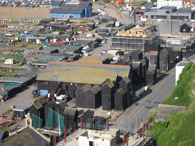
The Jerwood gallery is under construction behind, and a hotel in the foreground, and the fishing area and lifeboat station to the left.
The huts were used to store fishing nets and equipment. The weatherboarded structures were around 25 feet high and 8 feet square. Due to the lack of space the huts were restricted to 8 square feet at the base, so they were built tall.
There are around 43 remaining in Hastings, which were Grade II listed in the 1970s. Most are found to the Fishermans Stade along Rock-A-Nore Road There were once many more which were destroyed by storms or demolished in the 1950s for redevelopment.
A short dead end road at the Eastern side of the Old Town, Rock-a-Nore Road sits at the base of East Hill.
To the North side of the road are fish and chips shops, cafés and restaurants. Mid way along is the entrance to the East Hill Lift, Funicular Railway. A new hotel is also under construction.
To the South side is the Jerwood Gallery, fishing net huts, fish mongers, a museum in an old chapel, and at the end of the road is an aquarium.
Leading off the end of the road is a large car park.
The Jerwood site began construction in 2010. The site will create a permanent home for the Jerwood Art Collection, The Jerwood Gallery, and a new regional venue for the Jerwood Visual Arts programme on the Stade in Hastings, a 60 seat café, new toilets, and seafood kitchen, and a large open space for public events. The open space will include five circles representing the circles made by horse which used to winch the boats up the beach, before mechanisation.
The project caused much controversy because it was to be built on the only coach park in the Old Town, which brings in many tourists to the amusements adjacent.
The buildings design will be finished in black panelling similar to the surrounding fishing net huts, and two thirds of the site will be public open space.
The site could be consider officially complete on 17th March 2012 when the gallery was opened.
For more information about the gallery. Link
Also see images of the completed Jerwood Gallery Link and Eat @ The Stade Link
 Map © Crown Copyright")
- Grid Square
- TQ8209, 4355 images (more nearby 🔍)
- Photographer
- Oast House Archive (more nearby)
- Date Taken
- Monday, 9 May, 2011 (more nearby)
- Submitted
- Saturday, 14 May, 2011
- Subject Location
-
OSGB36:
 TQ 826 094 [100m precision]
WGS84: 50:51.3534N 0:35.6466E - Camera Location
-
OSGB36: TQ 827 095
- View Direction
- West-southwest (about 247 degrees)