2011
NS4870 : Dalmuir Light
taken 13 years ago, near to Clydebank, West Dunbartonshire, Scotland
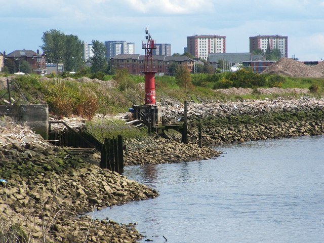
Dalmuir Light
This old beacon was photographed from a NS4870 : Walkway beside the River Clyde (it can be seen, although not very well, in the background of that image); see NS4870 : Dalmuir Light Beacon for another view. It is very similar in design to a beacon that stands at Old Kilpatrick; for that beacon, see NS4572 : Donald's Quay Light and NS4572 : Donald's Quay Light.
See the last of those links for a reference to their purpose; as noted there, both of the lights date from the nineteenth century, and they mark the location of bends in the river. For more on those lights, see NS4770 : Rashielee Light, which is also similar in design.
[An earlier map, c.1898, does show a "Dalmuir Light (fixed red)", but it was further downriver. However, that map does show another beacon, simply labelled "beacon", very close to the spot where the present Dalmuir Light is located; making allowance for refinements in positioning over the years, it may be the same spot.]
Originally (c.1914), the maps show Dalmuir Light as "flashing white"; by the 1960s, it is "flashing red", as at present. It is located on the north bank of the Clyde, between the former sites of two shipyards: Beardmore's, which was downriver, and John Brown's, which was upriver.
 Map © Crown Copyright")
TIP: Click the map for more Large scale mapping
- Grid Square
- NS4870, 214 images (more nearby 🔍)
- Photographer
- Lairich Rig (more nearby)
- Date Taken
- Friday, 10 June, 2011 (more nearby)
- Submitted
- Monday, 20 June, 2011
- Subject Location
-
OSGB36:
 NS 4896 7038 [10m precision]
WGS84: 55:54.1657N 4:25.0481W - Camera Location
-
OSGB36: NS 4883 7048
- View Direction
- Southeast (about 135 degrees)