2011
SD7513 : Affetside Cross, Watling Street
taken 13 years ago, near to Bradshaw, Bolton, England
This is 1 of 19 images, with title starting with Affetside in this square
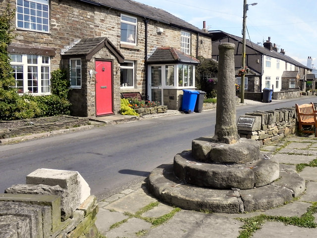
Affetside Cross, Watling Street
The cross at Affetside is a listed grade II structure, believed by many to be of Roman origin (possibly because of its proximity to the Roman road), supposedly marking the mid point between London and Edinburgh. English heritage, however suggest that its origins may be much later, perhaps 17th or 18th century. Link . Present thinking (Link ) considers it as a mediæval route marker for Lancashire pilgrims on route to Whalley Abbey.
The cross marks the route of the Roman road from Manchester to Ribchester, also known as Watling Street. The stone shaft has a socket cut into the top which originally supported a cross head or stone ball. The structure would have served as a market cross for Affetside and surrounding hamlets and possibly as a place for preaching and public proclamations. This form of standing cross would have been relatively common in mediæval settlements. However they were largely swept away in the upheavals of the Reformation during the mid 16th and 17th centuries, making Affetsides cross a relatively rare survival.
Affetside Cross is designated as a scheduled Ancient Monument under the provisions of the Ancient Monuments and Archaeological Areas Act of 1979 (National Monument 25721).
SD7513 : Roman Cross at Affetside shows a picture of the cross taken in 1976.
There is an interesting account of the history of Affetside and its cross on the wikipedia page Link
 Map © Crown Copyright")
TIP: Click the map for more Large scale mapping
- Grid Square
- SD7513, 82 images (more nearby 🔍)
- Photographer
- David Dixon (more nearby)
- Date Taken
- Thursday, 14 July, 2011 (more nearby)
- Submitted
- Friday, 15 July, 2011
- Subject Location
-
OSGB36:
 SD 7546 1369 [10m precision]
WGS84: 53:37.1503N 2:22.3475W - Camera Location
-
OSGB36: SD 7544 1370
- View Direction
- Southeast (about 135 degrees)