2011
NS4278 : Moorland near Maryland Farm
taken 13 years ago, 3 km from Bonhill, West Dunbartonshire, Scotland
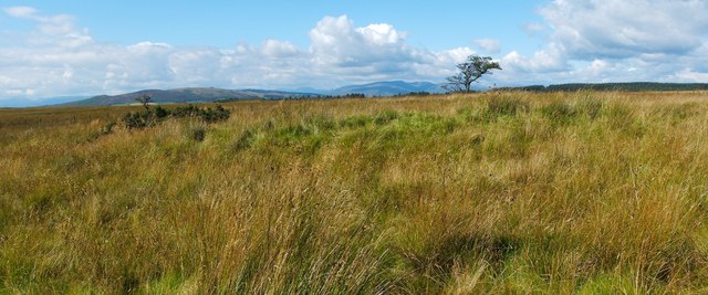
Moorland near Maryland Farm
The area shown here is on the high ground between the valley of the Spouts Burn (to the SE) and NS4278 : Auchenreoch Glen (to the NW).
I examined the small greenish area in the middle distance, shown at the centre of the photo, which was a little higher than its surroundings. It turned out to be higher because it is flanked by some old tracks.
There is a braid of tracks here; these, in turn, are just part of a very extensive system that evidently connected sites related to the local limestone industry (active here mainly in the eighteenth century). The tracks at this point lead directly north-east; at a point about 1.6 km in that direction, the braid of tracks combines into a single deeper track, which is much more visible: NS4379 : Ancient trackway (that item explains where the system of tracks can be viewed more clearly on satellite imagery).
In the background of the present photograph, a hawthorn tree, right of centre, stands on an NS4277 : Old field boundary. Distant Glen Finlas (centred on NS3289) is behind and just to the left of the tree). Considerably nearer, in the left-hand side of the image, are Carman Hill (NS3779) and neighbouring muirs.
 Map © Crown Copyright")
TIP: Click the map for more Large scale mapping
- Grid Square
- NS4278, 100 images (more nearby 🔍)
- Photographer
- Lairich Rig (more nearby)
- Date Taken
- Monday, 5 September, 2011 (more nearby)
- Submitted
- Tuesday, 20 September, 2011
- Subject Location
-
OSGB36:
 NS 4234 7817 [10m precision]
WGS84: 55:58.2337N 4:31.6677W - Camera Location
-
OSGB36: NS 4235 7816
- View Direction
- Northwest (about 315 degrees)