SX9372 : Wall and gratings at Gate No.10
taken 13 years ago, near to Shaldon, Devon, England
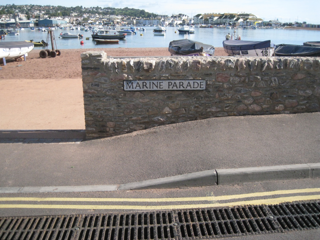
Shaldon and Ringmore tidal flood defence scheme
Shaldon and Ringmore are neighbouring villages by the Teign estuary. Houses, shops and hotels front the foreshore, reached by lanes and alleyways. There was a risk of tidal flooding to a basin behind the old informal defences, with two near-escapes in October 2004 and March 2008. The £8.3 million tailor-made scheme reduces the risk of tidal flooding to 453 homes and businesses. The Parish Council will operate the flood gates with 40 volunteer flood wardens.
Work started in January 2010 when the Environment Agencys contractors moved into Shaldon to raise 940 metres of existing foreshore walls, construct 470 metres of new foreshore wall, install ten floodgates and 25 flood windows and doors together with steps and ramps at specific locations. The work is of high quality that fits into the townscape by using local materials. The project employed a number of ground-breaking engineering techniques. Simple-looking walls in places conceal sheet piling that was installed with relatively quiet specialist equipment. Environmental enhancements were undertaken where opportunities allowed. A pumping station and outfall were included to resolve surface water issues.
The scheme was completed in May 2011. It was the first example of Building Trust with Communities, the Environment Agencys approach to public engagement. Construction traffic in the villages was reduced by siting the contractors main compound at Broadmeadow in Teignmouth across the river. The contractors staff won praise from residents for their cheerful and considerate conduct. The flood defences were officially opened on Friday, 1 July 2011. The event marked the end of seven years work by the Environment Agency and its contractors, Interserve.
Funding for the scheme came from the Department for Environment, Food and Rural Affairs (Defra) through the South West Regional Flood Defence Committee. The scheme has won two national awards, a Silver Considerate Contractor Award for the considerate manner in which the works were carried out and an Environment Agency award for Exemplar Safety, Health and Environment Performance. Only four national awards of this level are awarded each year.
Text adapted from the Environment Agencys website LinkA report to Teignbridge District Council's Development Control Committee, 28 September 2009, was published as a Google Doc: Link
 Map © Crown Copyright")
- Grid Square
- SX9372, 1938 images (more nearby 🔍)
- Photographer
- Robin Stott (more nearby)
- Date Taken
- Thursday, 15 September, 2011 (more nearby)
- Submitted
- Friday, 23 September, 2011
- Subject Location
-
OSGB36:
 SX 9354 7222 [10m precision]
WGS84: 50:32.4018N 3:30.2234W - Camera Location
-
OSGB36: SX 9354 7222
- View Direction
- Northeast (about 45 degrees)