2011
NZ3528 : Ceddesfield Hall, Rectory Road, Sedgefield
taken 13 years ago, near to Sedgefield, County Durham, England
This is 1 of 2 images, with title Ceddesfield Hall, Rectory Road, Sedgefield in this square
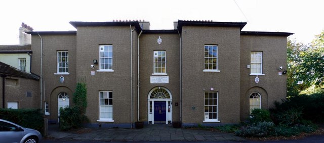
Ceddesfield Hall, Rectory Road, Sedgefield
The former Rectory was built in 1793 by Admiral Samuel Barrington and Bishop Shute Barrington for their nephew, the Reverend George Barrington, so that he could live 'in the manner to which he was accustomed'. It was converted in 1973 by the local Community Association for community use and renamed Ceddesfield Hall. The medieval rectory here which burnt down in 1793 was reputedly haunted by 'The Pickled Parson' who, some say, still resides in a lost tunnel leading from St Edmund's Church to the Rectory Link
The name, 'Ceddesfeld', was the old name for Sedgefield recorded in documentary sources in the years 915 and 1050. It is Anglo-Saxon in origin and may simply mean "Cedds' Field" or alternatively may reflect the nature of the surrounding area which, before land improvement, was damp and marshy, and often referred to as 'sedge'.
National Heritage List for England Entry Number: 1160001 Link
Sedgefield Heritage Trail
On a good day, the town looks very pretty and has much of interest. A good place to start is the Heritage Trail which is available on the web Link
 Map © Crown Copyright")
TIP: Click the map for more Large scale mapping
- Grid Square
- NZ3528, 120 images (more nearby 🔍)
- Photographer
- Andrew Curtis (more nearby)
- Date Taken
- Friday, 7 October, 2011 (more nearby)
- Submitted
- Saturday, 8 October, 2011
- Subject Location
-
OSGB36:
 NZ 3565 2874 [10m precision]
WGS84: 54:39.1503N 1:26.9395W - Camera Location
-
OSGB36: NZ 3565 2877
- View Direction
- SOUTH (about 180 degrees)