2011
ST6316 : Sherborne Abbey
taken 13 years ago, near to Sherborne, Dorset, England
This is 1 of 24 images, with title Sherborne Abbey in this square
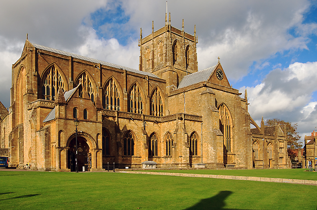
Sherborne Abbey
Arguably the finest building in Dorset it dates from the time when in AD 705 the Diocese of Winchester was divided in two, and Aldhelm, Abbot of Malmesbury was appointed the first Bishop of the West Saxons. When it was built the new cathedral served St Aldhelm and a succession of Saxon Bishops until the Norman Conquest, after which the Bishop's seat was moved to Old Sarum, and later Salisbury. Earlier in AD 998, monks of the Order of St Benedict had replaced the secular canons of the new cathedral, and they remained here until 1539 when Sherborne Abbey was surrendered to Henry VIII.
The Abbey and its estate was subsequently acquired by Sir John Horsey Link who after the Dissolution sold the Abbey to the town for use as a much needed replacement for their inadequate parish church of All Hallows. The Abbey as we see it today is largely the result of rebuilding that took place during the C15 when the choir, the nave, and the north transept was completed. The Abbey was sensitively restored in 1850-8, and the tower in 1884, thanks to a public subscription, and the generosity of the Digby family.
The Abbey and its estate was subsequently acquired by Sir John Horsey Link who after the Dissolution sold the Abbey to the town for use as a much needed replacement for their inadequate parish church of All Hallows. The Abbey as we see it today is largely the result of rebuilding that took place during the C15 when the choir, the nave, and the north transept was completed. The Abbey was sensitively restored in 1850-8, and the tower in 1884, thanks to a public subscription, and the generosity of the Digby family.
 Map © Crown Copyright")
TIP: Click the map for more Large scale mapping
- Grid Square
- ST6316, 834 images (more nearby 🔍)
- Photographer
- Mike Searle (more nearby)
- Date Taken
- Thursday, 6 October, 2011 (more nearby)
- Submitted
- Sunday, 9 October, 2011
- Subject Location
-
OSGB36:
 ST 638 164 [100m precision]
WGS84: 50:56.7806N 2:30.9909W - Camera Location
-
OSGB36: ST 638 164
- View Direction
- Northeast (about 45 degrees)