2011
NS4075 : Round Riding Road
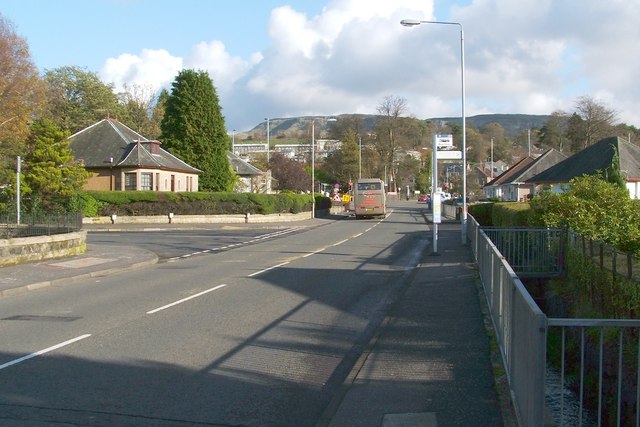
taken 12 years ago, near to Bellsmyre, West Dunbartonshire, Scotland
This is 1 of 2 images, with title Round Riding Road in this square
Round Riding Road
The photograph was taken near the eastern end of the road, where it meets the A82, at the foot of Garshake Road.
Round Riding Road follows the same line as a road shown on the first-edition OS map (c.1860), although there were only a few buildings alongside it at that time. The road is not named on that map, but other writings of the time show that it was then called Roundredding Road. Very similar spellings of the name appear on earlier maps from the 1740s to the 1820s (see Link for the details).
The Pont/Blaeu map of the Lennox (published in 1654, but based on surveys carried out in the 1580s-90s) shows a "Barundridain" here. That name is presumably the ancestor of the later forms "Roundredding" and "Round Riding".
Returning to what is visible in the photograph, the turning for Kilpatrick View is just ahead, on the left. The escarpment visible in the background is NS4376 : The Long Crags. The distant area of housing, located on the slopes in front of the escarpment, just left of centre, is the eastern end of Bellsmyre (compare, for example, NS4176 : Garshake Avenue, Bellsmyre).
On the right, between the pavement and the houses, is a fenced-off area, where a burn flows parallel to the road (and towards the photographer's position). It is not named on the map, but is the Knowle Burn, which had formed the eastern boundary of the medieval burgh.
For a view in the opposite direction along the same road, see NS4075 : Round Riding Road.
 Map © Crown Copyright")
TIP: Click the map for more Large scale mapping
- Grid Square
- NS4075, 195 images (more nearby 🔍)
- Photographer
- Lairich Rig (more nearby)
- Date Taken
- Tuesday, 1 November, 2011 (more nearby)
- Submitted
- Friday, 18 November, 2011
- Subject Location
-
OSGB36:
 NS 4080 7586 [10m precision]
WGS84: 55:56.9592N 4:33.0647W - Camera Location
-
OSGB36: NS 4072 7584
- View Direction
- East-northeast (about 67 degrees)