TQ7669 : Lower Boat Store, Chatham Historic Docks
taken 12 years ago, near to Brompton, Medway, England
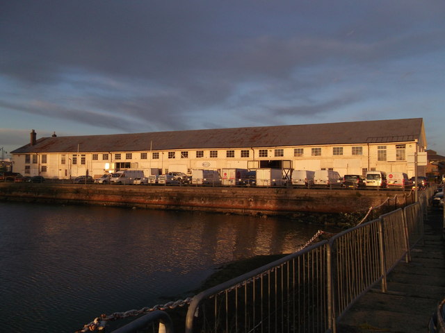
Used for various purposes including a storage firm (hence the trucks).
As seen across the Mast Pond (another listed structure).
The Chatham Dockyard's history dates back to 16th century and earlier. For centuries it was at the forefront of shipbuilding, and industrial and architectural technology and for 414 years, it provided over 500 ships to the Royal Navy. At its height the site covered over 400 acres.
The dockyard closed in 1984, and the now a 84 acre section of the site is a visitor attraction managed by the Chatham Historic Dockyard
Trust.
Wikipedia Link
Listed buildings and structures are officially designated as being of special architectural, historical or cultural significance. There are over half a million listed structures in the United Kingdom, covered by around 375,000 listings.
Listed status is more commonly associated with buildings or groups of buildings, however it can cover many other structures, including bridges, headstones, steps, ponds, monuments, walls, phone boxes, wrecks, parks, and heritage sites, and in more recent times a road crossing (Abbey Road) and graffiti art (Banksy 'Spy-booth') have been included.
In England and Wales there are three main listing designations;
Grade I (2.5%) - exceptional interest, sometimes considered to be internationally important.
Grade II* (5.5%) - particularly important buildings of more than special interest.
Grade II (92%) - nationally important and of special interest.
There are also locally listed structures (at the discretion of local authorities) using A, B and C designations.
In Scotland three classifications are also used but the criteria are different. There are around 47,500 Listed buildings.
Category A (8%)- generally equivalent to Grade I and II* in England and Wales
Category B (51%)- this appears generally to cover the ground of Grade II, recognising national importance.
Category C (41%)- buildings of local importance, probably with some overlap with English Grade II.
In Northern Ireland the criteria are similar to Scotland, but the classifications are:
Grade A (2.3%)
Grade B+ (4.7%)
Grade B (93%)
Read more at Wikipedia Link
 Map © Crown Copyright")
- Grid Square
- TQ7669, 402 images (more nearby 🔍)
- Photographer
- David Anstiss (more nearby)
- Date Taken
- Tuesday, 13 December, 2011 (more nearby)
- Submitted
- Tuesday, 13 December, 2011
- Subject Location
-
OSGB36:
 TQ 7623 6963 [10m precision]
WGS84: 51:23.8997N 0:31.9175E - Camera Location
-
OSGB36: TQ 7622 6955
- View Direction
- NORTH (about 0 degrees)