2012
TM0066 : Pillbox by the side of Wheeler's Lane
taken 12 years ago, near to Long Thurlow, Suffolk, England
Pillbox by the side of Wheeler's Lane
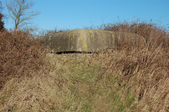
Largely hidden beneath the brambles and forming part of the old airfield defences, a type I don't recognise.
I am now told that this is a control centre for co-ordinating the defence of the airfield rather than a simple pillbox. The structure is largely subterranean, consisting of two separate "rooms" and the observation cupola which is the bit shown in the photograph. This type of fortification was apparently entered via a trap door at ground level but any evidence of such an entrance is now buried under a mound of earth and prickly vegetation.
I am now told that this is a control centre for co-ordinating the defence of the airfield rather than a simple pillbox. The structure is largely subterranean, consisting of two separate "rooms" and the observation cupola which is the bit shown in the photograph. This type of fortification was apparently entered via a trap door at ground level but any evidence of such an entrance is now buried under a mound of earth and prickly vegetation.
 Map © Crown Copyright")
TIP: Click the map for more Large scale mapping
- Grid Square
- TM0066, 7 images (more nearby 🔍)
- Photographer
- John Myers (more nearby)
- Date Taken
- Wednesday, 11 January, 2012 (more nearby)
- Submitted
- Thursday, 12 January, 2012
- Subject Location
-
OSGB36:
 TM 0059 6658 [10m precision]
WGS84: 52:15.6477N 0:56.2695E - Camera Location
-
OSGB36: TM 0059 6658
- View Direction
- Northeast (about 45 degrees)