2012
NT8515 : Russell's Cairn, Windy Gyle
taken 12 years ago, 4 km NNW of Barrowburn, Northumberland, England
This is 1 of 3 images, with title Russell's Cairn, Windy Gyle in this square
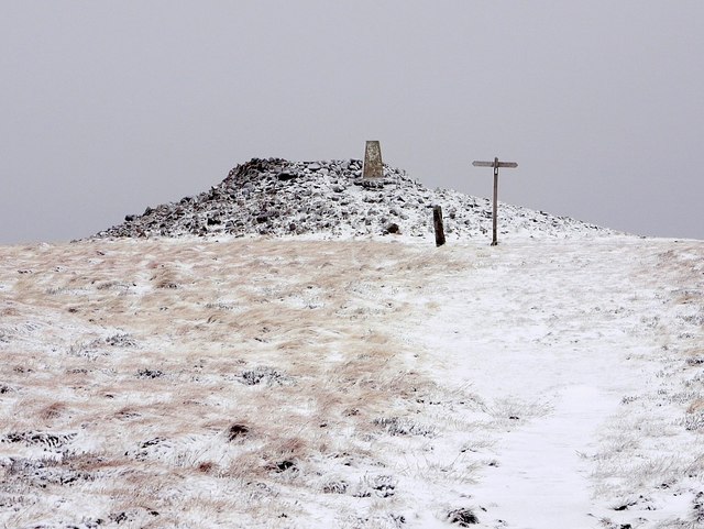
Russell's Cairn, Windy Gyle
Just south-west of the 619m summit of Windy Gyle is the place name "Split the De'il". David Dippie Dixon (Upper Coquetdale, 1903) describes this as an upright rock, some three feet in height. Another contradictory report describes an upright slab of porphyry, about 6 feet high, on the southern slope of Windy Gyle, in a south-easterly direction from the cairns.
The Modern Antiquarian: Link Archive Link
Pastscape describes it as a prehistoric standing stone at grid reference NT 8563 1502 a location where it is correctly shown on 1:10560 scale maps prior to 1925.
Archive Link
A later visit shows that 3 feet is the better description, the stone is no longer standing and unlikely to be prehistoric NT8515 : Split the De'il, Windy Gyle
The massive cairn, and others in the area are thought to be Bronze Age mounds. Russell's Cairn commemorates the spot where an Englishman, Lord Francis Russell, during a truce meeting with the Scottish Warden, Thomas Carre (or Ker), was killed by the Scots on the 28th July 1585. The Border was a lawless place. Russell's men were pursued for several miles onto English ground. The places 'Scotsman's Ford' and 'Bloodybush Edge' were named from the line of retreat.
From 'Windy Gyle', a poem by Geoff Holland:
"Beside this pile of stones
he died,
a Lord of long debated lands.
Four hundred years or more,
a border tryst
brought blood to stone."
Link Archive Link
The Modern Antiquarian: Link
Pastscape describes it as a prehistoric standing stone at grid reference NT 8563 1502 a location where it is correctly shown on 1:10560 scale maps prior to 1925.
Archive Link
A later visit shows that 3 feet is the better description, the stone is no longer standing and unlikely to be prehistoric NT8515 : Split the De'il, Windy Gyle
The massive cairn, and others in the area are thought to be Bronze Age mounds. Russell's Cairn commemorates the spot where an Englishman, Lord Francis Russell, during a truce meeting with the Scottish Warden, Thomas Carre (or Ker), was killed by the Scots on the 28th July 1585. The Border was a lawless place. Russell's men were pursued for several miles onto English ground. The places 'Scotsman's Ford' and 'Bloodybush Edge' were named from the line of retreat.
From 'Windy Gyle', a poem by Geoff Holland:
"Beside this pile of stones
he died,
a Lord of long debated lands.
Four hundred years or more,
a border tryst
brought blood to stone."
Link
 Map © Crown Copyright")
TIP: Click the map for more Large scale mapping
- Grid Square
- NT8515, 51 images (more nearby 🔍)
- Photographer
- Andrew Curtis (more nearby)
- Date Taken
- Friday, 20 January, 2012 (more nearby)
- Submitted
- Monday, 23 January, 2012
- Subject Location
-
OSGB36:
 NT 8553 1521 [10m precision]
WGS84: 55:25.8341N 2:13.8124W - Camera Location
-
OSGB36: NT 8555 1514
- View Direction
- North-northwest (about 337 degrees)