NM8504 : Road-making in the forest
taken 12 years ago, near to Ford, Argyll And Bute, Scotland
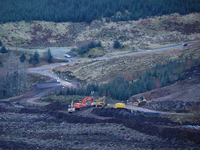
The West Loch Awe Timber Haul Route (WLATHR) is a 35km (22 miles) timber haul route that is being jointly developed by The Forestry Commission and GreenPower (Carraig Gheal) Ltd. The road will be used for turbine component delivery to the 46MW Carraig Gheal wind farm site and provide a strategic route in perpetuity for timber haulage through the Inverliever, Inverinan and Nant forests. Much of the route comprises existing forestry roads in place as part of the strategic timber transport route network, although upgrading is required for wind turbine component loads.
The majority of funding is coming from GreenPower (Carraig Gheal) Ltd with additional co-finance from Forestry Commission Scotland and Argyll and Bute Council. Forestry Commission Scotland have awarded £1,000,000 towards the overall £5,300,000 cost from the Strategic Timber Transport Fund.
The southern limit of the WLATHR is on the A816 at Salachary and the northern limit on the B845 at Kilchrenan. When complete, the road will take about 4,200 timber lorry movements each year off the single-track roads that serve the villages of Ford, Dalavich, Inverinan and Kilchrenan. The road serves four large blocks of forestry with a forecast timber harvest of 105,000 m3/year.
The road is due for completion at the end of September 2012 and the first wind turbines are due to arrive at the Carraig Gheal site in September 2012.
The two projects the wind farm and the WLATHR have a website at Link.
 Map © Crown Copyright")
- Grid Square
- NM8504, 43 images (more nearby 🔍)
- Photographer
- Patrick Mackie (more nearby)
- Date Taken
- Sunday, 29 January, 2012 (more nearby)
- Submitted
- Saturday, 4 February, 2012
- Subject Location
-
OSGB36:
 NM 8542 0449 [10m precision]
WGS84: 56:11.0731N 5:27.5600W - Camera Location
-
OSGB36: NM 8604 0460
- View Direction
- WEST (about 270 degrees)