2012
NT2673 : Edinburgh Castle from the top of Cat Nick gully, Salisbury Crags
taken 12 years ago, near to Edinburgh, Scotland
This is 1 of 74 images, with title starting with Edinburgh in this square
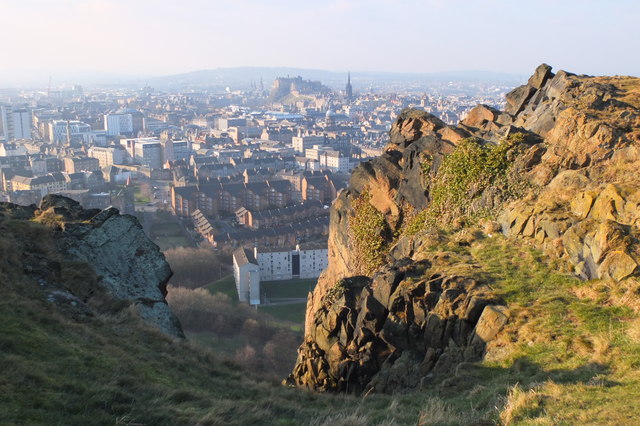
Edinburgh Castle from the top of Cat Nick gully, Salisbury Crags
This prominent gully exits near the highest point of the long facade of Salisbury Crags, with a superb view across the city.
In 1897 the climber Harold Raeburn published an article describing climbs complete with a map based on the 25 inch OS sheet. The Cat Nick gully is an ancient and well-known route to the top of the Crags from the Radical Road, well worn and polished by the hands, feet and knees of generations of youthful climbers. (Scottish Mountaineering Club Journal, vol 4, 335-341, 1897). In the same journal, W Inglis Clark noted a hair-raising winter ascent of the gully in powder snow, in shoes and without gloves, in January 1897.
In 1897 the climber Harold Raeburn published an article describing climbs complete with a map based on the 25 inch OS sheet. The Cat Nick gully is an ancient and well-known route to the top of the Crags from the Radical Road, well worn and polished by the hands, feet and knees of generations of youthful climbers. (Scottish Mountaineering Club Journal, vol 4, 335-341, 1897). In the same journal, W Inglis Clark noted a hair-raising winter ascent of the gully in powder snow, in shoes and without gloves, in January 1897.
 Map © Crown Copyright")
TIP: Click the map for more Large scale mapping
- Grid Square
- NT2673, 2367 images (more nearby 🔍)
- Photographer
- Jim Barton (more nearby)
- Date Taken
- Friday, 3 February, 2012 (more nearby)
- Submitted
- Saturday, 4 February, 2012
- Subject Location
-
OSGB36:
 NT 2675 7320 [10m precision]
WGS84: 55:56.7740N 3:10.4657W - Camera Location
-
OSGB36: NT 2675 7320
- View Direction
- WEST (about 270 degrees)