2012
NZ1762 : Blaydon Burn valley
taken 12 years ago, near to Blaydon, Gateshead, England
This is 1 of 2 images, with title Blaydon Burn valley in this square
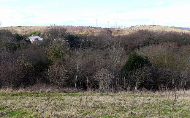
Blaydon Burn valley
From the C19th industrial development expanded rapidly along the Blaydon Burn to include a number of industries related to the processing of coal. The supply of cheap local fuel and good transport links led to the development of coke works, steelworks, iron foundries and brickworks making Blaydon Burn one of the most industrialised parts of the region.
Sir Joseph Cowen (1800-1873) and his son, also Joseph (1829-1900) made their money manufacturing bricks and clay products in the Blaydon Burn yards Link
Joseph Cowen, the elder, was a leading advocate of parliamentary reform and was Liberal MP for Newcastle from 1865-1873. Joseph Cowen junior NZ2464 : Cross House, Westgate Road was MP for Newcastle 1873-1886, and because of a reputation for plain speaking was given the nickname The Cowen Brick NZ1763 : Cowen firebrick and iron slag, Blaydon Burn
Large areas of former industrial activity were reclaimed in the late 1970s and early 1980s, with some subsequent landscaping. A footpath and cycleway runs through the valley, approximately following the course of the former Blaydon Burn Waggonway. Today, the remnants of the area's industrial history can still be seen in the 108 different stone and brick-built features which are scattered throughout the area of the heavily wooded nature reserve. The remains and historical records make Blaydon Burn one of the most important sites for the study of industrial archaeology in the north east.
Impoverished grassland managed for wild flowers, wetlands and mature trees in small areas of ancient woodland make the valley an important area for wildlife. Butterfly species included the rarities: White Letter Hairstreak, Purple Hairstreak and Dingy Skipper.
Gateshead Council began the three year long Blaydon Burn Project in 2007 to conserve, improve and promote Blaydon Burn for people and wildlife.
Whickham Area News: Link
Blaydon Burn Trail leaflet: Link
Blaydon Burn Industrial Landscape Assessment: Link
Roly Veitch's Website: Link
Joseph Cowen by Brickfrog: Link
The Flipside of Regeneration: Link Archive Link
See other images of Blaydon Burn Nature Reserve
Sir Joseph Cowen (1800-1873) and his son, also Joseph (1829-1900) made their money manufacturing bricks and clay products in the Blaydon Burn yards Link
Joseph Cowen, the elder, was a leading advocate of parliamentary reform and was Liberal MP for Newcastle from 1865-1873. Joseph Cowen junior NZ2464 : Cross House, Westgate Road was MP for Newcastle 1873-1886, and because of a reputation for plain speaking was given the nickname The Cowen Brick NZ1763 : Cowen firebrick and iron slag, Blaydon Burn
Large areas of former industrial activity were reclaimed in the late 1970s and early 1980s, with some subsequent landscaping. A footpath and cycleway runs through the valley, approximately following the course of the former Blaydon Burn Waggonway. Today, the remnants of the area's industrial history can still be seen in the 108 different stone and brick-built features which are scattered throughout the area of the heavily wooded nature reserve. The remains and historical records make Blaydon Burn one of the most important sites for the study of industrial archaeology in the north east.
Impoverished grassland managed for wild flowers, wetlands and mature trees in small areas of ancient woodland make the valley an important area for wildlife. Butterfly species included the rarities: White Letter Hairstreak, Purple Hairstreak and Dingy Skipper.
Gateshead Council began the three year long Blaydon Burn Project in 2007 to conserve, improve and promote Blaydon Burn for people and wildlife.
Whickham Area News: Link
Blaydon Burn Trail leaflet: Link
Blaydon Burn Industrial Landscape Assessment: Link
Roly Veitch's Website: Link
Joseph Cowen by Brickfrog: Link
The Flipside of Regeneration: Link
See other images of Blaydon Burn Nature Reserve
 Map © Crown Copyright")
TIP: Click the map for more Large scale mapping
- Grid Square
- NZ1762, 21 images (more nearby 🔍)
- Photographer
- Andrew Curtis (more nearby)
- Date Taken
- Friday, 24 February, 2012 (more nearby)
- Submitted
- Saturday, 25 February, 2012
- Subject Location
-
OSGB36:
 NZ 1721 6299 [10m precision]
WGS84: 54:57.6750N 1:43.9656W - Camera Location
-
OSGB36: NZ 1726 6296
- View Direction
- West-northwest (about 292 degrees)