2012
NT8712 : Landscape around Fairhaugh
taken 12 years ago, near to Barrowburn, Northumberland, England
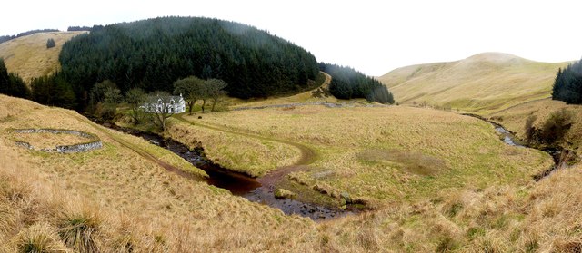
Landscape around Fairhaugh
The Usway Burn here executes a sharp turn as it becomes headed in between high hills. A track running behind the house follows its valley, to its junction with the River Coquet at Shillmoor. Another track ascends through the wood to eventually join Clennell Street which keeps to higher land above the valleys.
Fairhaugh is an C18th, stone built farmhouse set in a remote and beautiful location now used for holiday lets, sleeping 8 people. A ford provides vehicle access to the house, although there is a footbridge just upstream NT8712 : Footbridge at Fairhaugh.
The brochure Link (Archive Link ) describes access by "8 miles of forest roads, and when there's no snow and it's not too wet, motor access by car is quite achievable, so long as your car is fairly rugged". There is no electricity but heating is provided by wood burning stoves, lighting and cooking by gas.
According to Keys to the Past (Reference number: N550) "A building has stood at this site since the 13th century. People lived there until 1960." The earliest reference was in 1245 (Newminster Cartulary) and is also referred to in a deed dated 1642.
A second entry (Reference number: N13986) describes "An 18th or 19th century building at Fairhaugh. It is a small house in a very isolated setting. Precise dating of the house is impossible because the walls are covered in a coat of render." It was the sole house in Fairhaugh Township in 1828.
The OS Name Book for Alwinton (c1860) states "This name applies to a one storey house having a garden, and a farm of moorland attached, the property of Miss R. Scott."
Fairhaugh is an C18th, stone built farmhouse set in a remote and beautiful location now used for holiday lets, sleeping 8 people. A ford provides vehicle access to the house, although there is a footbridge just upstream NT8712 : Footbridge at Fairhaugh.
The brochure Link
According to Keys to the Past (Reference number: N550) "A building has stood at this site since the 13th century. People lived there until 1960." The earliest reference was in 1245 (Newminster Cartulary) and is also referred to in a deed dated 1642.
A second entry (Reference number: N13986) describes "An 18th or 19th century building at Fairhaugh. It is a small house in a very isolated setting. Precise dating of the house is impossible because the walls are covered in a coat of render." It was the sole house in Fairhaugh Township in 1828.
The OS Name Book for Alwinton (c1860) states "This name applies to a one storey house having a garden, and a farm of moorland attached, the property of Miss R. Scott."
 Map © Crown Copyright")
TIP: Click the map for more Large scale mapping
- Grid Square
- NT8712, 38 images (more nearby 🔍)
- Photographer
- Andrew Curtis (more nearby)
- Date Taken
- Friday, 16 March, 2012 (more nearby)
- Submitted
- Tuesday, 20 March, 2012
- Subject Location
-
OSGB36:
 NT 8722 1212 [10m precision]
WGS84: 55:24.1710N 2:12.2015W - Camera Location
-
OSGB36: NT 8750 1225
- View Direction
- West-southwest (about 247 degrees)