2012
TQ8327 : Norman Font, St Peter's church, Newenden
taken 12 years ago, near to Newenden, Kent, England
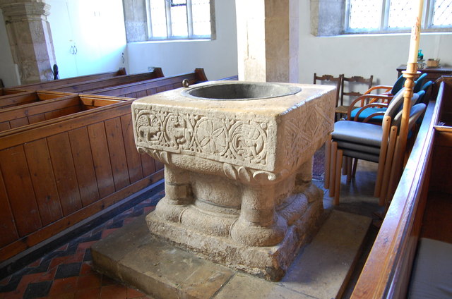
Norman Font, St Peter's church, Newenden
Grade II* listed.
The church dates from the 14th C. and was originally larger than present. It fell into disrepair, at the end of the 17th C. maybe by fire or an earthquake, but the chancel collapsed along with the tower at the north west.
A plain wall was erected at the east end in 1700 and the church was without a chancel for some 200 years until the 1930s, when work began on building a replacement.
Deep foundations had to be laid, and a neo-Norman style was built. During excavations, and old vault was uncovered and the bodies of two persons were found.
There is 14th C. arcading to the south, with one arch blocked, and there is a small north aisle. There is a small parvise which was used as a prison until 1780.
A new tall and slender tower was built in 1859 and contains a single bell from Mears foundry of 1860.
The church contains a remarkable 12th Century font with striking carvings on 3 sides including a head licking a leaf and three grotesque beasts. The chamber organ dates from the 18th Century.
See other images of St Peter's church, Newenden
 Map © Crown Copyright")
TIP: Click the map for more Large scale mapping
- Grid Square
- TQ8327, 202 images (more nearby 🔍)
- Photographer
- Julian P Guffogg (more nearby)
- Date Taken
- Saturday, 24 March, 2012 (more nearby)
- Submitted
- Saturday, 24 March, 2012
- Subject Location
-
OSGB36:
 TQ 8343 2730 [10m precision]
WGS84: 51:0.9492N 0:36.8233E - Camera Location
-
OSGB36: TQ 8342 2730
- View Direction
- North-northeast (about 22 degrees)