TQ3054 : North Downs Way on Oakley Hill (2)
taken 12 years ago, near to Chaldon, Surrey, England
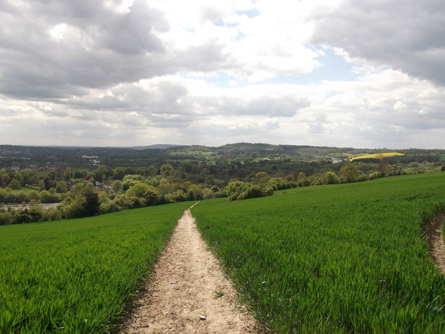
Merstham and Redhill are seen in the background.
On the far left and far right, the M25 can just be seen.
The Pilgrims' Way is a 120 mile historic route running between Winchester in Hampshire and Folkestone, Kent. The route is supposed to have been taken by pilgrims from Winchester to the shrine of Thomas Becket at Canterbury in Kent, but actually goes to the South of Canterbury to Folkestone. Archaeological finds date it at least to 500-400 BC, and as far back as the Stone Age.
Nowadays the route goes through quiet countryside as well as busy roads. The trail parallels other routes including the North Downs Way.
For more information Link
A long distance path in southern England. It runs from Farnham to Dover, past Godalming, Guildford, Dorking, Merstham, Otford and Rochester, along the Surrey Hills Area of Outstanding Natural Beauty (AONB) and Kent Downs AONB. East of Boughton Lees, the path splits in two, the northern section running via Canterbury and the southern via Wye. The two sections of the path reunite at Dover. The northern route is 211 km long, and the southern route 201 km, the total length of the North Downs Way being 246 km.
The pathway is mixed in that it varies throughout its length from footpath status to bridleway, byway and road. Some 19% of the Way follows roads, though 75% of those are minor lanes. It is marked by an acorn. See TQ6561 : Crossover in Long Distance pathways.
See Link
The M25 is a 117 mile orbital motorway that encircles London. It was constructed between 1975 and 1986.
The motorway is not a continuous loop as a section to the East of London at The Dartford Crossing is an A-Road.
Wikipedia; Link
 Map © Crown Copyright")
- Grid Square
- TQ3054, 58 images (more nearby 🔍)
- Photographer
- David Anstiss (more nearby)
- Date Taken
- Wednesday, 16 May, 2012 (more nearby)
- Submitted
- Sunday, 20 May, 2012
- Subject Location
-
OSGB36:
 TQ 3055 5418 [10m precision]
WGS84: 51:16.3095N 0:7.7951W - Camera Location
-
OSGB36: TQ 3057 5419
- View Direction
- West-southwest (about 247 degrees)