2012
NS3974 : Dumbarton Rock: War Department boundary stone no. 1
taken 12 years ago, near to Dumbarton, West Dunbartonshire, Scotland
This is 1 of 6 images, with title starting with Dumbarton Rock: War Department boundary stone no in this square
Dumbarton Rock: War Department boundary stone no. 1
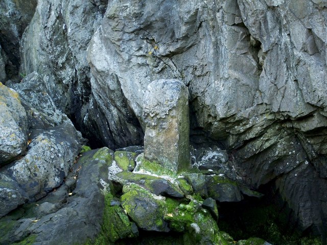
This stone is about a metre high, and it is located within one of the Rock's small western bays, accessible at or near low water. The appearance of the stone and of its base (which was apparently formed by cementing together blocks of volcanic tuff taken from the immediate vicinity) suggests that it was set in place here well over a century ago.
Its position corresponds to what is denoted on the second-edition OS map (1897) by a dot, labelled "B.S.W.D. No. 1"; the map also shows B.S.W.D. Nos. 2 through 9; unlike the stone shown in the present photograph, those other sites are not on the shore, but are arranged in sequence, winding around the northern side of the Rock to end at its eastern side.
Late in 2011, I had noticed a shorter upright stone that had the appearance of a boundary marker; it is not far to the north-east of stone No. 1. I had recorded its position, and found, when researching the present item, that it was located at the point where "B.S.W.D. No. 3" is marked on the 1897 map. On the day after I submitted the present photograph, I set out to photograph No. 3 (the light had been too poor on the occasion when I first noticed it), and I also located and photographed two more of the boundary stones, making four in total. It occurred to me, while doing this, that B.S.W.D. most probably stands for "Boundary Stone (War Department)", and this does indeed turn out to be the case. The surviving markers at Dumbarton Rock are not all of the same size or design.
I looked for the remaining markers a short time later. As it turns out, stones 1-6 are all still in place. Stone 1 is the subject of the present photograph, and the others are as follows:
NS3974 : Dumbarton Rock: War Department boundary stone no. 2 and NS3974 : Dumbarton Rock: War Department boundary stone no. 2.
NS3974 : Dumbarton Rock: War Department boundary stone no. 3 and NS3974 : Dumbarton Rock: War Department boundary stone no. 3.
NS3974 : Dumbarton Rock: War Department boundary stone no. 4.
NS4074 : Dumbarton Rock: War Department boundary stone no. 5.
NS4074 : Dumbarton Rock: War Department boundary stone no. 6.
(Stones 2 and 4 are quite different from stone 1, but fairly similar to each other; however, stone 4 is much more worn than stone 2. Stones 3, 5 and 6 are also very similar to each other in shape.)
Stones 7-9, which were all located close to Castle Road, do not appear to survive in place. They were probably removed in connection with work carried out either on the road or on the industrial sites that used to lie just to the east of the road.
For an example of the same kind of boundary marker elsewhere, see TR3750 : War Department boundary stone, Walmer Castle.
Dumbarton Rock and Castle :: NS4074
The Rock is a volcanic plug, and it has a long history as a fortified site. For further information, see the Geograph article "Dumbarton Rock and Castle": Link
War Department boundary stones at Dumbarton Rock
The 25" second-edition OS map, surveyed in 1897, shows a series of nine locations, labelled B.S.W.D. № 1 to № 9, leading around the base of the Rock from west, via north, to east. Delimiting land under military rather than Burgh jurisdiction, these stones, which are diverse in size and in design, probably date from the 1850s/1860s.
 Map © Crown Copyright")
TIP: Click the map for more Large scale mapping
- Grid Square
- NS3974, 267 images (more nearby 🔍)
- Photographer
- Lairich Rig (more nearby)
- Date Taken
- Friday, 25 May, 2012 (more nearby)
- Submitted
- Monday, 4 June, 2012
- Subject Location
-
OSGB36:
 NS 3986 7450 [10m precision]
WGS84: 55:56.2080N 4:33.9185W - Camera Location
-
OSGB36: NS 3986 7450
- View Direction
- EAST (about 90 degrees)