TL5864 : Devil's Dyke footpath crosses the B1102
taken 12 years ago, near to Swaffham Prior, Cambridgeshire, England
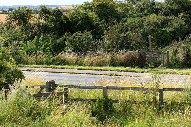
The Devil's Dyke is one of the best preserved Anglo-Saxon earthworks of its kind in the country dating from the 5th or 6th century AD. It consists of a 7.5 miles (12.1 km) long bank and ditch running in a south-east direction from the village of Reach to Woodditton. When it was created, it sealed a narrow land corridor between the southern edge the then undrained and water-logged fenland in the north-west, and dense woodlands in the south, so making circumvention difficult and forming an effective barrier. The dyke crossed three important Roman roads, including the ancient Icknield Way, and may thus have served as a way of controlling trade and movement in and out of the area.
It was probably built by the East Anglians against their Mercian neighbours. The Anglo-Saxon Chronicle and other sources record the frequently tense relations between the two kingdoms, and it is likely that this provoked the need to strengthen the border and control access.
It is a Scheduled Ancient Monument (SAM). It also contains chalk grassland of international importance and has been designated as a Site of Special Scientific Interest (SSSI) and part is a Special Area of Conservation (SAC).
Try Archive Linkfor more information.
 Map © Crown Copyright")
- Grid Square
- TL5864, 53 images (more nearby 🔍)
- Photographer
- Rob Noble (more nearby)
- Date Taken
- Saturday, 4 August, 2012 (more nearby)
- Submitted
- Sunday, 5 August, 2012
- Subject Location
-
OSGB36:
 TL 5801 6482 [10m precision]
WGS84: 52:15.5314N 0:18.8221E - Camera Location
-
OSGB36: TL 58036 64810
- View Direction
- West-northwest (about 292 degrees)