1981
J3474 : The River Lagan, Belfast (1981)
taken 43 years ago, near to Belfast, Co Antrim, Northern Ireland
The River Lagan, Belfast (1981)
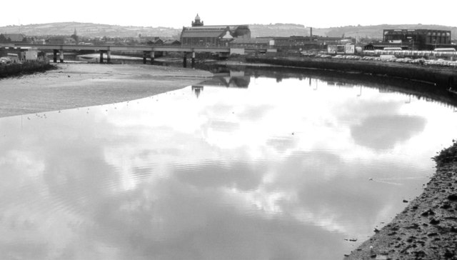
The view upstream from the Queens Bridge. The (now demolished) power station at East Bridge Street J3473 : Old gate pillars and wall, Belfast is at the middle top. Oxford Street bus station J3474 : Former Oxford Street bus station, Belfast is at top right. Well before the building of the weir J3474 : The Lagan Weir, Belfast and J3474 : Weir and cross-harbour bridges, Belfast (65) the Lagan was fully tidal here with inter-tidal mud on view. Despite its unsavoury reputation the mud provided food for gulls, oystercatchers and redshank. J3474 : The River Lagan, Belfast (2012) shows the same view in 2012.
Loading map... (JavaScript required)
- Grid Square
- J3474, 4349 images (more nearby 🔍)
- Photographer
- Albert Bridge (more nearby)
- Date Taken
- Monday, 24 August, 1981 (more nearby)
- Submitted
- Sunday, 5 August, 2012
- Subject Location
-
Irish:
 J 344 743 [100m precision]
WGS84: 54:35.9592N 5:55.2505W - Camera Location
-
Irish: J 344 743
- View Direction
- South-southeast (about 157 degrees)